IMAGES TAKEN NEAR TO
Heol Y Mynydd, AMMANFORD, SA18 2RY
Introduction
This page details the photographs taken nearby to Heol Y Mynydd, SA18 2RY by members of the Geograph project.
The Geograph project started in 2005 with the aim of publishing, organising and preserving representative images for every square kilometre of Great Britain, Ireland and the Isle of Man.

There are currently over 7.5m images from over14,400 individuals and you can help contribute to the project by visiting https://www.geograph.org.uk
Image Map (Loading...)


Getting Data...Please wait
Leaflet Map data © OpenStreetMap
Images are licensed for reuse under creativecommons.org/licenses/by-sa/2.0
Notes
- Clicking on the map will re-center to the selected point.
- The higher the marker number, the further away the image location is from the centre of the postcode.
Image Listing (3 Images Found)
Images are licensed for reuse under creativecommons.org/licenses/by-sa/2.0
Image
Details
Distance
1
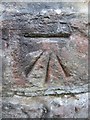
Ordnance Survey Cut Mark
This OS Cut Mark can be found on a wall to the south west of the mountain road in Garnswllt. It marks a point 92.3056m above mean sea level.
Image: © Adrian Dust
Taken: 21 Jul 2013
0.01 miles
2
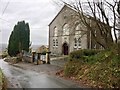
Noddfa Chapel
Noddfa Chapel, on the outskirts of Garnswllt.
Image: © Alan Hughes
Taken: 17 Dec 2018
0.03 miles
3
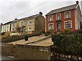
Housing in Garnswllt
Houses built in an elevated position overlooking the main road in Garnswllt.
Image: © Alan Hughes
Taken: 17 Dec 2018
0.11 miles