IMAGES TAKEN NEAR TO
Derwydd Road, AMMANFORD, SA18 2NX
Introduction
This page details the photographs taken nearby to Derwydd Road, SA18 2NX by members of the Geograph project.
The Geograph project started in 2005 with the aim of publishing, organising and preserving representative images for every square kilometre of Great Britain, Ireland and the Isle of Man.

There are currently over 7.5m images from over14,400 individuals and you can help contribute to the project by visiting https://www.geograph.org.uk
Image Map (Loading...)


Getting Data...Please wait
Leaflet Map data © OpenStreetMap
Images are licensed for reuse under creativecommons.org/licenses/by-sa/2.0
Notes
- Clicking on the map will re-center to the selected point.
- The higher the marker number, the further away the image location is from the centre of the postcode.
Image Listing (9 Images Found)
Images are licensed for reuse under creativecommons.org/licenses/by-sa/2.0
Image
Details
Distance
1
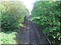
Derwydd Road railway station (site), Carmarthenshire
Opened on an unknown date on the 'Llanelly Railway's line from Llanelli to Llandeilo, this station closed in 1964 to passengers and completely in 1966.
View south east towards Llandybie and Llanelli from the same position as Image The trees have encroached somewhat in the intervening 22 years.
Image: © Nigel Thompson
Taken: 17 May 2014
0.04 miles
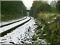
2

Derwydd Road railway station (site), Carmarthenshire
Opened in 1857 on the "Llanelly" Railway's line from Llanelli to Llandeilo, this station closed to passengers in 1954 and completely in 1966.
View south at the site of the entrance. The railway line is to the right of the bushes. The building would have been roughly where the coal pile is, with a goods siding to the left of the second gate.
Image: © Nigel Thompson
Taken: 17 May 2014
0.04 miles
3
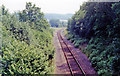
Site of former Derwydd Road station
View SE, towards Pantyfynnon, Pontadulais, Llanelli/Swansea: ex-GWR Llandilo - Llanelly section of the ex-LNW Central Wales - now 'Heart of Wales' Line, Craven Arms Llandrindod - Llandovery -Llandilo - Swansea (Victoria)/since 6/64 Llanelli. This station was closed to passengers 3/5/64, to goods 14/3/66.
Image: © Ben Brooksbank
Taken: 27 Jun 1992
0.04 miles
4
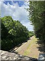
Former railway station at Derwydd near Llandybie
All that remains of the station is the crumbling stone retaining wall on the right of the photo. Presumably this was part of the platform. This photo is taken from a point where a public right of way descends from the platform and crosses the line.
Image: © Nigel Davies
Taken: 27 Nov 2005
0.06 miles
6

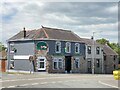
Glan Cennen Ganol
Farm building and storage area at Glan Cennen Ganol.
Image: © Alan Hughes
Taken: 18 Mar 2019
0.18 miles
7
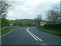
A483 at College Bridge and Derwydd village boundary sign
Image: © Colin Pyle
Taken: 5 May 2012
0.21 miles
9
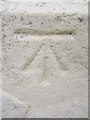
Ordnance Survey Cut Mark
This OS cut mark can be found on No1 Cennen Terrace. It marks a point 77.8743m above mean sea level.
Image: © Adrian Dust
Taken: 24 Aug 2013
0.25 miles