IMAGES TAKEN NEAR TO
Foundry Road, AMMANFORD, SA18 2LS
Introduction
This page details the photographs taken nearby to Foundry Road, SA18 2LS by members of the Geograph project.
The Geograph project started in 2005 with the aim of publishing, organising and preserving representative images for every square kilometre of Great Britain, Ireland and the Isle of Man.

There are currently over 7.5m images from over14,400 individuals and you can help contribute to the project by visiting https://www.geograph.org.uk
Image Map
Images are licensed for reuse under creativecommons.org/licenses/by-sa/2.0
Notes
- Clicking on the map will re-center to the selected point.
- The higher the marker number, the further away the image location is from the centre of the postcode.
Image Listing (39 Images Found)
Images are licensed for reuse under creativecommons.org/licenses/by-sa/2.0
Image
Details
Distance
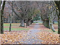
1
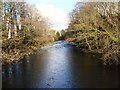
River Aman looking upstream from the road bridge
Image: © Ruth Sharville
Taken: 5 Feb 2010
0.04 miles
2
Derelict platform of the old GWR railway station, Ammanford
Image: © Ruth Sharville
Taken: 5 Feb 2010
0.06 miles
3

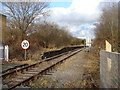
Ammanford (GW) railway station (site), Carmarthenshire
Opened in 1840 as Cross Inn by the "Llanelly Railway" on the line from Pantyffynnon to Brynamman, this station closed in 1958. The station name had changed to Ammanford in 1883.
View NE towards the former Ammanford Colliery Halt and Brynamman from a public crossing. The line was only used by freight trains when this image was taken. The current Ammanford station is a short distance away on the Central Wales Line.
Image: © Nigel Thompson
Taken: 17 May 2014
0.07 miles
4
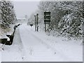
Snow covered railway out of Ammanford
This formerly disused mineral line is used to transfer coal from a reopened mine near Tairgwaith. Looks like the train isn't running today though.
Also in shot are the remains of the platform to the left of the track from when Ammanford Station was here, and the practice tower at the fire station in the distance.
Image: © Nigel Davies
Taken: 17 Dec 2010
0.07 miles
7
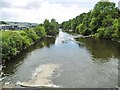
Betws, River Amman
Looking downstream from Betws Bridge.
Image: © Mike Faherty
Taken: 14 Jul 2016
0.08 miles
8
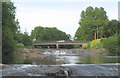
Bridge over Amman river, joining Ammanford and Betws
At the end of a street called Quay St, near the centre of a town called Ammanford would you expect to find a Quay or a Ford ? Wrong - it's a bridge.
Image: © Nigel Davies
Taken: 21 Jun 2005
0.08 miles
9
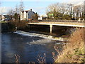
Bridge over the River Aman, Ammanford
The highest of the three weirs in this immediate reach of the river can also be seen. See my shots for Image
Image: © Ruth Sharville
Taken: 5 Feb 2010
0.09 miles
10
Miners' Memorial, Ammanford
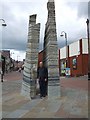
This memorial by Howard Bowcott was commissioned in memory of the hundreds of miners who lost their lives in pit disasters or accidents when the coal industry was the major employer in this area. It is composed of layers of slate and sandstone to represent the coalseams; the names of the dead are engraved around it. It was erected in 2006 at the bottom of Quay Street, a busy shopping precinct.
Image: © Natasha Ceridwen de Chroustchoff
Taken: 4 Oct 2006
0.09 miles