IMAGES TAKEN NEAR TO
Llandeilo Road, AMMANFORD, SA18 2LQ
Introduction
This page details the photographs taken nearby to Llandeilo Road, SA18 2LQ by members of the Geograph project.
The Geograph project started in 2005 with the aim of publishing, organising and preserving representative images for every square kilometre of Great Britain, Ireland and the Isle of Man.

There are currently over 7.5m images from over14,400 individuals and you can help contribute to the project by visiting https://www.geograph.org.uk
Image Map (Loading...)


Getting Data...Please wait
Leaflet Map data © OpenStreetMap
Images are licensed for reuse under creativecommons.org/licenses/by-sa/2.0
Notes
- Clicking on the map will re-center to the selected point.
- The higher the marker number, the further away the image location is from the centre of the postcode.
Image Listing (2 Images Found)
Images are licensed for reuse under creativecommons.org/licenses/by-sa/2.0
Image
Details
Distance
1
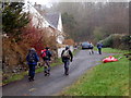
Pistyll Canol
Cerddwyr yn agosau at anhedd-dy o'r enw Pistyll Canol.
Walkers approaching a property known as Pistyll Canol (trans. middle spring).
Image: © Alan Richards
Taken: 12 Feb 2012
0.09 miles