IMAGES TAKEN NEAR TO
Rhodfa Frank, AMMANFORD, SA18 2LP
Introduction
This page details the photographs taken nearby to Rhodfa Frank, SA18 2LP by members of the Geograph project.
The Geograph project started in 2005 with the aim of publishing, organising and preserving representative images for every square kilometre of Great Britain, Ireland and the Isle of Man.

There are currently over 7.5m images from over14,400 individuals and you can help contribute to the project by visiting https://www.geograph.org.uk
Image Map (Loading...)


Getting Data...Please wait
Leaflet Map data © OpenStreetMap
Images are licensed for reuse under creativecommons.org/licenses/by-sa/2.0
Notes
- Clicking on the map will re-center to the selected point.
- The higher the marker number, the further away the image location is from the centre of the postcode.
Image Listing (86 Images Found)
Images are licensed for reuse under creativecommons.org/licenses/by-sa/2.0
Image
Details
Distance
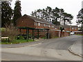
1
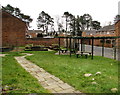
Community area in a suburban corner of Ammanford
On the corner of Rhodfa Frank and Heol Haydn.
Image: © Jaggery
Taken: 11 Feb 2015
0.01 miles
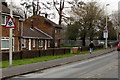
2
Houses between Rhodfa Frank and Heol Haydn in Ammanford
Looking east across Rhodfa Frank.
Image: © Jaggery
Taken: 11 Feb 2015
0.02 miles
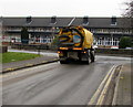
3
Wet streaks on Rhodfa Frank, Ammanford
A street cleaning vehicle http://www.geograph.org.uk/photo/4345401 passed by a few seconds earlier.
Image: © Jaggery
Taken: 11 Feb 2015
0.03 miles
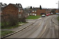
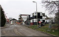
4
Rhodfa Frank, Gwyn Fryn Estate, Ammanford
On the north side of Station Road and Dyffryn Road. Rhodfa is Welsh for avenue.
Image: © Jaggery
Taken: 11 Feb 2015
0.03 miles
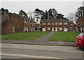
5

Rhodfa Frank electricity substation in Ammanford
The Western Power Distribution electricity substation is inside a brick
enclosure on the east side of Rhodfa Frank, north of the Station Road junction.
Image: © Jaggery
Taken: 11 Feb 2015
0.03 miles
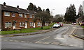
6
Heol Haydn, Gwyn Fryn Estate, Ammanford
On the east side of Rhodfa Frank.
Image: © Jaggery
Taken: 11 Feb 2015
0.04 miles
7
Construction site at the northern end of Rhodfa Frank in Ammanford
Viewed in February 2015. A Google Earth Street View taken in July 2011 shows a road and green fields here.
Image: © Jaggery
Taken: 11 Feb 2015
0.05 miles
8
Cleaning up in Ammanford
In February 2015, a street cleaning vehicle is cleaning up mud from the road surface
south of this http://www.geograph.org.uk/photo/4345349 Rhodfa Frank construction site behind the camera.
Image: © Jaggery
Taken: 11 Feb 2015
0.06 miles
9
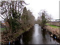
Upstream along the Loughor, Ammanford
River north of Station Road.
Image: © Jaggery
Taken: 11 Feb 2015
0.06 miles
10
Puzzling road sign, Station Road, Ammanford
The triangular snow warning sign is fixed to a lamppost in a low-lying (about 35 metres above sea level) usually mild area of West Wales, where lying snow is rare in most winters. Why is it here?
Image: © Jaggery
Taken: 11 Feb 2015
0.07 miles