IMAGES TAKEN NEAR TO
Maesquarre Road, AMMANFORD, SA18 2LE
Introduction
This page details the photographs taken nearby to Maesquarre Road, SA18 2LE by members of the Geograph project.
The Geograph project started in 2005 with the aim of publishing, organising and preserving representative images for every square kilometre of Great Britain, Ireland and the Isle of Man.

There are currently over 7.5m images from over14,400 individuals and you can help contribute to the project by visiting https://www.geograph.org.uk
Image Map (Loading...)


Getting Data...Please wait
Leaflet Map data © OpenStreetMap
Images are licensed for reuse under creativecommons.org/licenses/by-sa/2.0
Notes
- Clicking on the map will re-center to the selected point.
- The higher the marker number, the further away the image location is from the centre of the postcode.
Image Listing (8 Images Found)
Images are licensed for reuse under creativecommons.org/licenses/by-sa/2.0
Image
Details
Distance
1
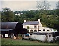
Maes-Ifan
This is Maes-Ifan a farm of seven acres, or should one say was, it was demolished and no trace of it now today.
Image: © Anthony Gostling
Taken: Unknown
0.06 miles
2
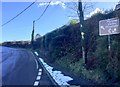
Mountain Road
Sign on Maercwarrau Road at the foot of Mynydd Betws.
Image: © Alan Hughes
Taken: 2 Feb 2019
0.09 miles
3
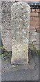
Old Milestone in Maesquarre Road, Ammanford
Old milestone in front of 53 Maesquarre Road, Ammanford.
Inscription once read:- : Llandeilo / Fawr / 8 / Swansea / 14 :
Milestone Society National ID: CAM_LOSW08
Image: © Kirstie Hackett
Taken: 18 Feb 2020
0.17 miles
4
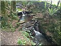
Small Waterfall on Nant y Ffin
A public footpath leaves Heol Waun Ddwfn heading south, upstream alongside Nant y Ffin. Not long afterwards it passes this little waterfall (and the adjacent abandoned brick machine house)
See also: Image
Image: © Nigel Davies
Taken: 3 Jun 2022
0.19 miles
5
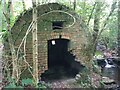
Odd Machine House by Nant y Ffin
A public footpath leaves Heol Waun Ddwfn heading south, upstream alongside Nant y Ffin. Not long afterwards it passes a little waterfall next to which sits this abandoned machine house. Inside, the arched brick structure is now empty but the floor looks to have had a platform for machinery. The door is on the downstream wall and there are holes - some original - in the upstream and riverside walls too.
See also: Image
Image: © Nigel Davies
Taken: 3 Jun 2022
0.19 miles

7

Ordnance Survey Cut Mark
This OS Cut Mark can be found on the brick wall to the west of the steps to No8 Wern Terrace. It marks a point 121.2708m above mean sea level.
Image: © Adrian Dust
Taken: 30 Jun 2013
0.24 miles
8
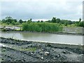
Pools at former Betws Colliery
These and the spoil heaps are all that remain from the colliery. The rest is being redeveloped for business units and residences.
Image: © Nigel Davies
Taken: 6 Jul 2008
0.24 miles