IMAGES TAKEN NEAR TO
Parc Nant Y Felin, AMMANFORD, SA18 2JZ
Introduction
This page details the photographs taken nearby to Parc Nant Y Felin, SA18 2JZ by members of the Geograph project.
The Geograph project started in 2005 with the aim of publishing, organising and preserving representative images for every square kilometre of Great Britain, Ireland and the Isle of Man.

There are currently over 7.5m images from over14,400 individuals and you can help contribute to the project by visiting https://www.geograph.org.uk
Image Map (Loading...)


Getting Data...Please wait
Leaflet Map data © OpenStreetMap
Images are licensed for reuse under creativecommons.org/licenses/by-sa/2.0
Notes
- Clicking on the map will re-center to the selected point.
- The higher the marker number, the further away the image location is from the centre of the postcode.
Image Listing (15 Images Found)
Images are licensed for reuse under creativecommons.org/licenses/by-sa/2.0
Image
Details
Distance
1
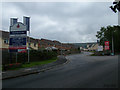
The New Betws Mine road "Today"
When the road was new - see Image
Image: © Anthony Gostling
Taken: 26 Jul 2008
0.04 miles
2
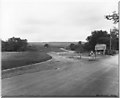
The new Betws mine road
The new road to Betws New Mine taken on 26 July 1974.
This is what it looks like in 2008 - Image
Image: © N.C.B
Taken: 26 Jul 1974
0.06 miles
3

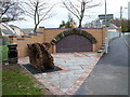
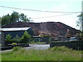
Ty Coch, Pontaman
Cerddwyr yn mynd heibio i Dy Coch House a fu'n gynt yn bencadlys i Gwmni Glo Rhydaman. Am flynyddoedd bu'r lle yn glwb nos. Mae'r lle bellach ar werth.
Walkers passing Ty Coch House (trans. red house) which was formerly the headquarters of Ammanford Coal Company. It has for years been a nightclub; it is currently for sale.
Image: © Alan Richards
Taken: 23 Feb 2014
0.06 miles
4

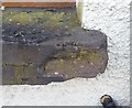
Ordnance Survey Cut Mark
This badly damaged Ordnance Survey Cut Mark can be found, for a little bit longer anyway, on the front of the Tycoch Club. It marks a point 56.3453m above mean sea level.
Image: © Adrian Dust
Taken: 20 Jun 2013
0.09 miles
5
Mine Memorial
Mine Memorial on Maesquarry Road
Image: © Anthony Gostling
Taken: 12 Nov 2009
0.12 miles
6
Ordnance Survey Pivot
This very damaged OS pivot (only left edge of arrow survives) can be found on the window sill of the Royal Kitchen. It marked a point 48.138m above mean sea level.
Image: © Adrian Dust
Taken: 20 Sep 2020
0.20 miles
7
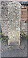
Old Milestone in Maesquarre Road, Ammanford
Old milestone in front of 53 Maesquarre Road, Ammanford.
Inscription once read:- : Llandeilo / Fawr / 8 / Swansea / 14 :
Milestone Society National ID: CAM_LOSW08
Image: © Kirstie Hackett
Taken: 18 Feb 2020
0.21 miles
8
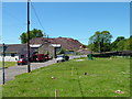
Work on the new Ammanford bypass at Pontamman
Image: © Anthony Gostling
Taken: 2 Jun 2006
0.22 miles
10
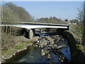
Pontamman Road Bridge
Road bridge over the river Amman at Pontamman. Taken from the old road bridge (SN639126).
Image: © Hywel Williams
Taken: 28 Mar 2002
0.23 miles