IMAGES TAKEN NEAR TO
Clos Y Felin, AMMANFORD, SA18 2JP
Introduction
This page details the photographs taken nearby to Clos Y Felin, SA18 2JP by members of the Geograph project.
The Geograph project started in 2005 with the aim of publishing, organising and preserving representative images for every square kilometre of Great Britain, Ireland and the Isle of Man.

There are currently over 7.5m images from over14,400 individuals and you can help contribute to the project by visiting https://www.geograph.org.uk
Image Map (Loading...)


Getting Data...Please wait
Leaflet Map data © OpenStreetMap
Images are licensed for reuse under creativecommons.org/licenses/by-sa/2.0
Notes
- Clicking on the map will re-center to the selected point.
- The higher the marker number, the further away the image location is from the centre of the postcode.
Image Listing (18 Images Found)
Images are licensed for reuse under creativecommons.org/licenses/by-sa/2.0
Image
Details
Distance
1
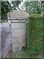
Ordnance Survey Cut Mark
This Ordnance Survey Cut Mark can be found on the right pillar of No40 Cwmamman Road. It marks a point 59.5610m above mean sea level.
Image: © Adrian Dust
Taken: 20 Jun 2013
0.06 miles
2
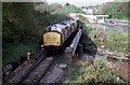
Train on the bridge
Empty wagons head back west after delivering coal to the washery at Abernant. This line has seen no movements of coal for a long while and is mothballed. At this time there were still up to half a dozen movements a day on the branch line moving coal.
Note the Jet Petrol Station in the background. How much was petrol then?
Image: © roger geach
Taken: 11 Aug 1989
0.09 miles
3
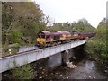
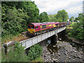
Train crossing Pontamman railway bridge
A scene that hasn't been witnessed for some time until a recent refurbishment allowed the Amman Valley railway line to once again carry coal. This train is travelling back down the valley with 25 wagons full of coal.
The bridge has a plate on it stating that it was built in 1877.
The locomotive seen here is a Class 66 (number 66083) - known as the "Shed" because of their end-on profile or "Ying-ying" due to the sound they make. They're a very common goods diesel locomotive in South Wales. Prior to being mothballed, the line was served by Type 37 locos, known as Growlers or Tractors, due to their deep chugging sound - as seen by a photograph taken from almost exactly the same location in 1989. Image
Image: © Hywel Williams
Taken: 28 Apr 2009
0.10 miles
4
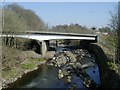
Railway bridge over the River Amman in Pontamman
Image: © Gareth James
Taken: 12 Jul 2018
0.16 miles
5
Coal train in Pontamman
Class 66 No. 66187 crosses the River Amman with a loaded coal train from Gwaun-cae-Gurwen for Swansea Burrows sidings.
Image: © Gareth James
Taken: 12 Jul 2018
0.16 miles
6
Ordnance Survey Pivot
This very damaged OS pivot (only left edge of arrow survives) can be found on the window sill of the Royal Kitchen. It marked a point 48.138m above mean sea level.
Image: © Adrian Dust
Taken: 20 Sep 2020
0.17 miles
7

Sundog / Parhelia
A phenomenon seen when fine ice crystals in the upper atmosphere refracts the sun's rays. A halo (parhelic circle) forms at 22º around the sun when it's close to the horizon on crisp evenings (just visible in this photograph) and two "mock suns" appear on either side of the sun at 90º and 270º, often being seen as two tiny rainbows.
The sun in this picture is way overexposed causing it to seem bloated (and actually damaged the camera's CCD while taking this picture!)
Image: © Hywel Williams
Taken: 19 Oct 2002
0.17 miles
8
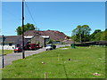
Work on the new Ammanford bypass at Pontamman
Image: © Anthony Gostling
Taken: 2 Jun 2006
0.19 miles
9
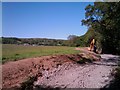
Cycle Path Construction
For a number of years, a "cycle path", part of the SUSTRANS network has existed between Ammanford and Garnant that had no start or destination - you could only access it via a narrow suspension bridge over the river Amman.Image
Work has since been done to extend this path up the Amman Valley but for a while it stopped about 1 kilometre short of Ammanford. Now, work is underway to complete the rest of this path. This is listed as National Route 437 and will shortly start from just west of Pontamman bridge to Glanamman with a view to eventually extending the route all the way to Brynamman.
Planning documents also suggest that this work is also being carried out to re-route existing public rights of way routes away from nearby farm buildings by providing new clearly defined paths that replace the ill defined (and in some cases almost impassable) current routes.
Image: © Hywel Williams
Taken: 23 May 2010
0.20 miles
10
Pontamman Road Bridge
Road bridge over the river Amman at Pontamman. Taken from the old road bridge (SN639126).
Image: © Hywel Williams
Taken: 28 Mar 2002
0.20 miles