IMAGES TAKEN NEAR TO
Betws, AMMANFORD, SA18 2HR
Introduction
This page details the photographs taken nearby to SA18 2HR by members of the Geograph project.
The Geograph project started in 2005 with the aim of publishing, organising and preserving representative images for every square kilometre of Great Britain, Ireland and the Isle of Man.

There are currently over 7.5m images from over14,400 individuals and you can help contribute to the project by visiting https://www.geograph.org.uk
Image Map (Loading...)


Getting Data...Please wait
Leaflet Map data © OpenStreetMap
Images are licensed for reuse under creativecommons.org/licenses/by-sa/2.0
Notes
- Clicking on the map will re-center to the selected point.
- The higher the marker number, the further away the image location is from the centre of the postcode.
Image Listing (2 Images Found)
Images are licensed for reuse under creativecommons.org/licenses/by-sa/2.0
Image
Details
Distance
1
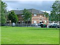
Betws rugby club
The purple structure against the wall looks exactly like a standard local bus shelter but without the timetable. I'd guess it is used as a smoker's gathering point.
Image: © Nigel Davies
Taken: 6 Jul 2008
0.13 miles
2
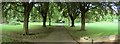
Betws Park, near Ammanford
The river Amman forms the west boundary of this park.
Image: © Nigel Davies
Taken: 21 Jun 2005
0.24 miles