IMAGES TAKEN NEAR TO
Llys Dolwerdd, AMMANFORD, SA18 2FB
Introduction
This page details the photographs taken nearby to Llys Dolwerdd, SA18 2FB by members of the Geograph project.
The Geograph project started in 2005 with the aim of publishing, organising and preserving representative images for every square kilometre of Great Britain, Ireland and the Isle of Man.

There are currently over 7.5m images from over14,400 individuals and you can help contribute to the project by visiting https://www.geograph.org.uk
Image Map (Loading...)


Getting Data...Please wait
Leaflet Map data © OpenStreetMap
Images are licensed for reuse under creativecommons.org/licenses/by-sa/2.0
Notes
- Clicking on the map will re-center to the selected point.
- The higher the marker number, the further away the image location is from the centre of the postcode.
Image Listing (6 Images Found)
Images are licensed for reuse under creativecommons.org/licenses/by-sa/2.0
Image
Details
Distance
1
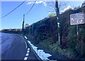
Mountain Road
Sign on Maercwarrau Road at the foot of Mynydd Betws.
Image: © Alan Hughes
Taken: 2 Feb 2019
0.16 miles
2
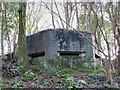
Front of Pillbox on Argoed Road
This view is uphill towards the front of the box. Argoed Road is immediately behind the trees.
Image: © Nigel Davies
Taken: 26 Dec 2013
0.18 miles
3
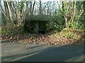
Pillbox Entrance on Argoed Road
This is a view of the door at the back of the pillbox immediately adjacent to the road.
Image: © Nigel Davies
Taken: 26 Dec 2013
0.18 miles
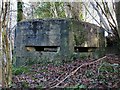
5
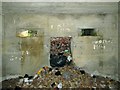
Interior of Pillbox on Argoed Road
This is a view in through the front slit towards the largely blocked door at the back, on the roadside.
Image: © Nigel Davies
Taken: 26 Dec 2013
0.18 miles
6
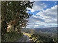
Country lane
The road descends via Maerdy and Betws to Ammanford.
Image: © Alan Hughes
Taken: 10 Feb 2021
0.24 miles