IMAGES TAKEN NEAR TO
Garnant, AMMANFORD, SA18 2EQ
Introduction
This page details the photographs taken nearby to SA18 2EQ by members of the Geograph project.
The Geograph project started in 2005 with the aim of publishing, organising and preserving representative images for every square kilometre of Great Britain, Ireland and the Isle of Man.

There are currently over 7.5m images from over14,400 individuals and you can help contribute to the project by visiting https://www.geograph.org.uk
Image Map (Loading...)


Getting Data...Please wait
Leaflet Map data © OpenStreetMap
Images are licensed for reuse under creativecommons.org/licenses/by-sa/2.0
Notes
- Clicking on the map will re-center to the selected point.
- The higher the marker number, the further away the image location is from the centre of the postcode.
Image Listing (6 Images Found)
Images are licensed for reuse under creativecommons.org/licenses/by-sa/2.0
Image
Details
Distance
1
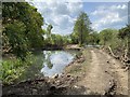
Tre Cynllaeth
Track past ponds at Tre Cynllaeth.
Image: © Alan Hughes
Taken: 4 May 2020
0.06 miles
2
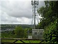
Masts above Glanaman
Glanaman is in a valley and its telecommunications needs are provided by masts at higher elevations. You can see a second mast Image on the skyline.
Image: © Marion Phillips
Taken: 27 Jul 2009
0.06 miles
3
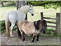
Keeping a watchful eye
Two very different breeds of horse. Is the smaller one a Shetland pony?
Image: © Alan Hughes
Taken: 4 May 2020
0.11 miles
4
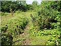
Country footpath
This is a waymarked path but walkers need suitable footwear as horses have been creating mud this wet July. Brambles, gorse and ragwort flourish but the grass has been grazed very short.
Image: © Marion Phillips
Taken: 27 Jul 2009
0.16 miles
5
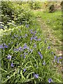
Bluebell-lined track
Bluebells lone the footpath leading to the wilder hills above Brynaman.
Image: © Alan Hughes
Taken: 4 May 2020
0.21 miles
6
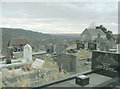
Hen Bethel Chapel near Garnant and Glanaman
On the side of the Black Mountain near Garnant and Glanamman is this little old chapel and graveyard.
Image: © Nigel Davies
Taken: 25 Dec 2005
0.24 miles