IMAGES TAKEN NEAR TO
Parc Henry Lane, AMMANFORD, SA18 2EL
Introduction
This page details the photographs taken nearby to Parc Henry Lane, SA18 2EL by members of the Geograph project.
The Geograph project started in 2005 with the aim of publishing, organising and preserving representative images for every square kilometre of Great Britain, Ireland and the Isle of Man.

There are currently over 7.5m images from over14,400 individuals and you can help contribute to the project by visiting https://www.geograph.org.uk
Image Map
Images are licensed for reuse under creativecommons.org/licenses/by-sa/2.0
Notes
- Clicking on the map will re-center to the selected point.
- The higher the marker number, the further away the image location is from the centre of the postcode.
Image Listing (2 Images Found)
Images are licensed for reuse under creativecommons.org/licenses/by-sa/2.0
Image
Details
Distance
1
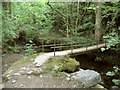
Footbridge over Loughor river, near Parc Henry
Image: © Nigel Davies
Taken: 19 Jun 2005
0.10 miles
2
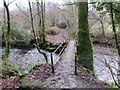
Pontdroed Parc Henry / Parc Henry Footbridge
Pontdroed yn rychwantu Afon Llwchwr gerllaw Ffarm Parc Henri.
Footbridge spanning the Llwchwr River near Parc Henry Farm (trans. henry's park / field)
Image: © Alan Richards
Taken: 9 Dec 2012
0.13 miles