IMAGES TAKEN NEAR TO
Florence Road, AMMANFORD, SA18 2DN
Introduction
This page details the photographs taken nearby to Florence Road, SA18 2DN by members of the Geograph project.
The Geograph project started in 2005 with the aim of publishing, organising and preserving representative images for every square kilometre of Great Britain, Ireland and the Isle of Man.

There are currently over 7.5m images from over14,400 individuals and you can help contribute to the project by visiting https://www.geograph.org.uk
Image Map (Loading...)


Getting Data...Please wait
Leaflet Map data © OpenStreetMap
Images are licensed for reuse under creativecommons.org/licenses/by-sa/2.0
Notes
- Clicking on the map will re-center to the selected point.
- The higher the marker number, the further away the image location is from the centre of the postcode.
Image Listing (99 Images Found)
Images are licensed for reuse under creativecommons.org/licenses/by-sa/2.0
Image
Details
Distance
1
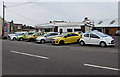
T K Beynon, Ammanford
Used car dealer in Llandybie Road, on the corner of Florence Road.
Image: © Jaggery
Taken: 1 May 2015
0.03 miles
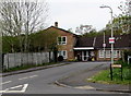
2
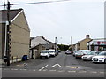
West along Florence Road, Ammanford
Viewed across Llandybie Road. T K Beynon used car dealer http://www.geograph.org.uk/photo/4455673 is on the right.
Image: © Jaggery
Taken: 1 May 2015
0.04 miles
3
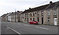
Two rows of houses, Llandybie Road, Ammanford
On the west side of the A483 Llandybie Road, viewed looking south towards the centre of Ammanford.
Image: © Jaggery
Taken: 1 May 2015
0.05 miles
4
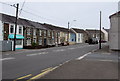
Llandybie Road near Arthur Street, Ammanford
The A483 Llandybie Road passes the right turn for Arthur Street.
Image: © Jaggery
Taken: 1 May 2015
0.05 miles
5
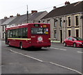
Old-style First bus heads towards Ammanford bus station
On bus route 103 from Llandybie, heading south along the A483 Llandybie Road in the north of Ammanford.
http://www.geograph.org.uk/photo/4457723 to another view of the bus and some details.
Image: © Jaggery
Taken: 1 May 2015
0.05 miles
6
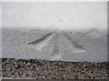
Ordnance Survey Pivot
This OS Pivot can be found on the windowsill of No60 Llandybie Rd. It marks a point 40.7180m above mean sea level.
Image: © Adrian Dust
Taken: 24 Aug 2013
0.06 miles
7
Inconspicuous takeaway, Llandybie Road, Ammanford
Strangely for a business, the takeaway on the left has a tiny name sign,
easily missed, unlike the conspicuous red Biffa general waste bin.
Image: © Jaggery
Taken: 1 May 2015
0.07 miles
8
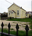
Former Elim Chapel, Llandybie Road, Ammanford
Converted to two dwellings.
Image: © Jaggery
Taken: 1 May 2015
0.07 miles
9
Nantlais, Ammanford
Houses on the west side of the A483 Llandybie Road.
Image: © Jaggery
Taken: 1 May 2015
0.08 miles
10
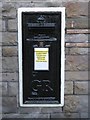
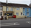
Closed Postbox at former Tirydail Post Office
Painted black and blocked off.
Image: © Nigel Davies
Taken: 11 Oct 2008
0.08 miles