IMAGES TAKEN NEAR TO
Station Road, AMMANFORD, SA18 2DD
Introduction
This page details the photographs taken nearby to Station Road, SA18 2DD by members of the Geograph project.
The Geograph project started in 2005 with the aim of publishing, organising and preserving representative images for every square kilometre of Great Britain, Ireland and the Isle of Man.

There are currently over 7.5m images from over14,400 individuals and you can help contribute to the project by visiting https://www.geograph.org.uk
Image Map (Loading...)


Getting Data...Please wait
Leaflet Map data © OpenStreetMap
Images are licensed for reuse under creativecommons.org/licenses/by-sa/2.0
Notes
- Clicking on the map will re-center to the selected point.
- The higher the marker number, the further away the image location is from the centre of the postcode.
Image Listing (108 Images Found)
Images are licensed for reuse under creativecommons.org/licenses/by-sa/2.0
Image
Details
Distance
1
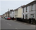
East side of Tir y Dail Lane, Ammanford
Looking north towards Station Road.
Image: © Jaggery
Taken: 1 May 2015
0.01 miles
2
Weight restriction along Tir-y-Dail Lane, Ammanford
A 7.5 tonnes vehicle weight limit applies ahead (except for access).
Image: © Jaggery
Taken: 11 Feb 2015
0.02 miles
3
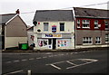
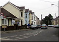
Amma Stores, Ammanford
Nisa Local convenience store at 31 Station Road.
Image: © Jaggery
Taken: 11 Feb 2015
0.02 miles
4
Sign for drivers of large or slow vehicles approaching Ammanford station level crossing
Alongside Station Road. Drivers of large or slow vehicles (as defined on the notice) must park here
and use the phone at the level crossing to obtain permission to cross the Heart of Wales Line railway.
Image: © Jaggery
Taken: 1 May 2015
0.02 miles
5
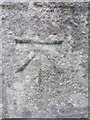
Ordnance Survey Cut Mark
This Ordnance Survey Cut Mark can be found on the front of the Great Western Public House. It marks a point 34.5918m above mean sea level.
Image: © Adrian Dust
Taken: 20 Jun 2013
0.04 miles
6
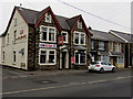
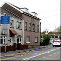
Great Western, Ammanford
Pub on the corner of Station Road and Brynderwen Road, opposite Ammanford railway station.
Image: © Jaggery
Taken: 11 Feb 2015
0.04 miles
7
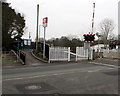
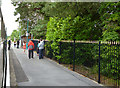
Entrance to Ammanford railway station
From Station Road, opposite Brynderwen Road and the Great Western pub. http://www.geograph.org.uk/photo/4345170
Image: © Jaggery
Taken: 11 Feb 2015
0.04 miles
8
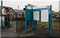
Information boards at Ammanford railway station
Near the station entrance from Station Road. Ammanford is on the Heart of Wales Line between Pantyffynnon station to the south and Llandybie station to the north. The turquoise colour shows that this station is managed by Arriva Trains Wales. The company also runs all the trains.
The station was originally part of the Llanelly Railway which was later absorbed by the LNWR (London and North Western Railway), which became part of the LMS (London, Midland and Scottish Railway) at the Grouping in 1923. The names show that the old railway companies were not limited to the areas in their name. This route from Shrewsbury to Swansea gave the LNWR a foothold in South Wales, which was mainly Great Western Railway territory.
Image: © Jaggery
Taken: 11 Feb 2015
0.04 miles
9
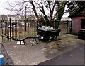
Old plough and coal truck on Ammanford railway station platform
Symbolising the development of Ammanford from a small agricultural community to a rapidly expanding town following the opening of coal mines and the arrival of the railway in 1840, linking the town with Llanelly (as Llanelli was then spelt in English).
Image: © Jaggery
Taken: 11 Feb 2015
0.04 miles
10
Ammanford station
Just one platform, with a simple waiting shelter, serves the single line in both directions.
Image: © Dr Neil Clifton
Taken: 27 Jul 2012
0.04 miles