IMAGES TAKEN NEAR TO
Brynmawr Lane, AMMANFORD, SA18 2BY
Introduction
This page details the photographs taken nearby to Brynmawr Lane, SA18 2BY by members of the Geograph project.
The Geograph project started in 2005 with the aim of publishing, organising and preserving representative images for every square kilometre of Great Britain, Ireland and the Isle of Man.

There are currently over 7.5m images from over14,400 individuals and you can help contribute to the project by visiting https://www.geograph.org.uk
Image Map (86 Images)


Getting Data...Please wait
Leaflet Map data © OpenStreetMap
Images are licensed for reuse under creativecommons.org/licenses/by-sa/2.0
Notes
- Clicking on the map will re-center to the selected point.
- The higher the marker number, the further away the image location is from the centre of the postcode.
Image Listing (86 Images Found)
Images are licensed for reuse under creativecommons.org/licenses/by-sa/2.0
Image
Details
Distance
1
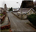
Brynmawr Lane, Ammanford
Looking SW towards College Street.
Image: © Jaggery
Taken: 11 Feb 2015
0.01 miles
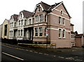
2
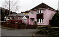
Pink house in Ammanford
Viewed across Brynmawr Lane.
Image: © Jaggery
Taken: 11 Feb 2015
0.01 miles
3
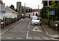
Brynmawr Lane, Ammanford
Viewed from College Street. All Saints church http://www.geograph.org.uk/photo/4346575 is in the background.
Image: © Jaggery
Taken: 11 Feb 2015
0.01 miles

6
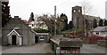
Baptist church and Anglican church in Ammanford
English Baptist Church in Brynmawr Lane on the left. All Saints Church in Wales church http://www.geograph.org.uk/photo/4346575 on the right.
Image: © Jaggery
Taken: 11 Feb 2015
0.06 miles
7
Llys Cennen Solicitors Ammanford Office
At 52 College Street, on the corner of Iscennen Road.
Image: © Jaggery
Taken: 11 Feb 2015
0.06 miles
8
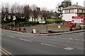
0.43 acres development site in Ammanford
The fenced-off area is on the corner of College Street and Margaret Street, opposite Ling Di Long. http://www.geograph.org.uk/photo/4344262
Viewed in February 2015. This is the site of the demolished former police station,
which was alongside the Magistrates' Court http://www.geograph.org.uk/photo/4344666 (now closed).
Image: © Jaggery
Taken: 11 Feb 2015
0.06 miles
9
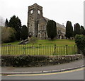
All Saints, Ammanford
Church in Wales church in the Parish of Betws St David with Ammanford in the Diocese of St Davids.
The main part of the building was constructed from 1911-1915.
The tower was completed as a War Memorial in the mid 1920s.
Image: © Jaggery
Taken: 11 Feb 2015
0.06 miles
10
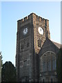
Ammanford Church Tower
The Flagstaff on the tower was used by the Ordnance Survey as a 3rd Order Triangulation Point (Intersected Station SN61/INT004).
Image: © Adrian Dust
Taken: 1 Apr 2012
0.06 miles