IMAGES TAKEN NEAR TO
Glanamman, AMMANFORD, SA18 2AJ
Introduction
This page details the photographs taken nearby to SA18 2AJ by members of the Geograph project.
The Geograph project started in 2005 with the aim of publishing, organising and preserving representative images for every square kilometre of Great Britain, Ireland and the Isle of Man.

There are currently over 7.5m images from over14,400 individuals and you can help contribute to the project by visiting https://www.geograph.org.uk
Image Map (Loading...)


Getting Data...Please wait
Leaflet Map data © OpenStreetMap
Images are licensed for reuse under creativecommons.org/licenses/by-sa/2.0
Notes
- Clicking on the map will re-center to the selected point.
- The higher the marker number, the further away the image location is from the centre of the postcode.
Image Listing (5 Images Found)
Images are licensed for reuse under creativecommons.org/licenses/by-sa/2.0
Image
Details
Distance
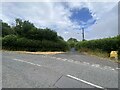
2
Ordnance Survey Cut Mark
This Ordnance Survey NBM Cut Mark can be found below the Letter Box in front of Nos 35 & 37 Tirycoed Road. It marks a point 100.5724m above mean sea level.
Image: © Adrian Dust
Taken: 11 Jun 2013
0.20 miles
3
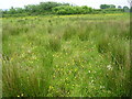
Ungrazed field
Flower-rich but ill-drained meadow.
Image: © Marion Phillips
Taken: 1 Jun 2010
0.22 miles
4
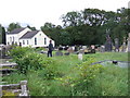
Tabernacle chapel and cemetery, Glanaman
Somewhere here lie the remains of James Colton, a Scottish miner who settled in the area and became in late life (1925) the husband of the renowned anarchist Emma Goldman. It may have been a marriage of political convenience, to give her citizenship after she had been stripped of hers and expelled from America, but their surviving letters are very affectionate. He died in 1936 and his grave is not marked.
Image: © Natasha Ceridwen de Chroustchoff
Taken: 4 Oct 2006
0.22 miles
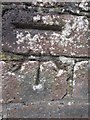
5
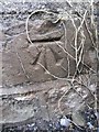
Ordnance Survey Cut Mark
This Ordnance Survey NBM Cut Mark can be found on the SW Parapet, NW Angle, NW Face of the small bridge on Tirycoed Road. It marks a point 108.5484m above mean sea level.
Image: © Adrian Dust
Taken: 11 Jun 2013
0.24 miles