IMAGES TAKEN NEAR TO
Glanamman, AMMANFORD, SA18 2AD
Introduction
This page details the photographs taken nearby to SA18 2AD by members of the Geograph project.
The Geograph project started in 2005 with the aim of publishing, organising and preserving representative images for every square kilometre of Great Britain, Ireland and the Isle of Man.

There are currently over 7.5m images from over14,400 individuals and you can help contribute to the project by visiting https://www.geograph.org.uk
Image Map (Loading...)


Getting Data...Please wait
Leaflet Map data © OpenStreetMap
Images are licensed for reuse under creativecommons.org/licenses/by-sa/2.0
Notes
- Clicking on the map will re-center to the selected point.
- The higher the marker number, the further away the image location is from the centre of the postcode.
Image Listing (5 Images Found)
Images are licensed for reuse under creativecommons.org/licenses/by-sa/2.0
Image
Details
Distance
1
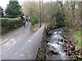
Afon Garenig River
Afon Garenig yn llifo'n gyfochrog â heol yng Nghlanaman.
The Garenig River flows parallel with a minor road in Glanaman.
Image: © Alan Richards
Taken: 23 Feb 2014
0.05 miles
2
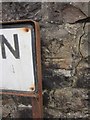
Ordnance Survey Cut Mark
This Ordnance Survey Cut Mark can be found on the roadside wall of No 1 Maes Ywern. It marks a point 112.2153m above mean sea level. It also seems to be up-side-down!
Image: © Adrian Dust
Taken: 20 Jun 2013
0.12 miles
3

Bridge on the road to Brunant, Glanaman
Image: © Anthony Gostling
Taken: 22 Apr 2006
0.21 miles
4
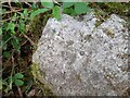
Ordnance Survey Rivet
This OS rivet can be found on the boulder NE side of the track. It marks a point 158.950m above mean sea level.
Image: © Adrian Dust
Taken: 9 May 2022
0.23 miles
5
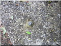
Ordnance Survey Rivet
This Ordnance Survey Rivet can be found on a concrete culvert on the SW side of the road. It marks a point 96.3686m above mean sea level.
Image: © Adrian Dust
Taken: 20 Jun 2013
0.23 miles