IMAGES TAKEN NEAR TO
Maes Gareth Edwards, AMMANFORD, SA18 1RU
Introduction
This page details the photographs taken nearby to Maes Gareth Edwards, SA18 1RU by members of the Geograph project.
The Geograph project started in 2005 with the aim of publishing, organising and preserving representative images for every square kilometre of Great Britain, Ireland and the Isle of Man.

There are currently over 7.5m images from over14,400 individuals and you can help contribute to the project by visiting https://www.geograph.org.uk
Image Map (4 Images)


Leaflet Map data © OpenStreetMap
Images are licensed for reuse under creativecommons.org/licenses/by-sa/2.0
Notes
- Clicking on the map will re-center to the selected point.
- The higher the marker number, the further away the image location is from the centre of the postcode.
Image Listing (4 Images Found)
Images are licensed for reuse under creativecommons.org/licenses/by-sa/2.0
Image
Details
Distance
1
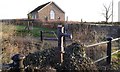
Water Pump
An old water pump now stands disused on Brynamman Road. Behind the pump is Hermon Independent Chapel, built in 1905.
Image: © Hywel Williams
Taken: 1 Dec 2019
0.09 miles
2
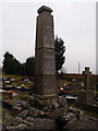
Bedd Alfa / Alfa's grave, Brynaman
Bedd crand y Parchedig William 'Alfa' Richards (1875-1931), bardd ac emynydd, ym mynwent Capel Hermon, Brynaman. Cyhoeddodd ddwy gyfrol o farddoniaeth 'Blodau'r Groes (1907) a 'Clychau'r Wawr (1910) ond mae e'n cael ei gofio orau fel awdur yr emyn poblogaidd hwnnw i blant 'Rwy'n canu fel cana'r aderyn'.
The large imposing gravestone of the Reverend William 'Alfa' Richards (1875-1931), poet and hymn writer, at Hermon Chapel, Brynaman. He published two volumes of verse 'Blodau'r Groes' (Flowers of the Cross) and Clychau'r Wawr (Bells of Dawn) but he is best remembered for his very popular children's hymn 'Rwyn canu fel cana'r aderyn' (I sing as does the bird).
Image: © Alan Richards
Taken: 18 Jan 2012
0.12 miles
4
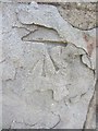
Ordnance Survey Cut Mark
This damaged OS Cut Mark can be found on the front of No23 Brynamman Road. It marks a point 171.5800m above mean sea level.
Image: © Adrian Dust
Taken: 7 Jul 2013
0.21 miles