IMAGES TAKEN NEAR TO
Llwynhen Road, AMMANFORD, SA18 1RG
Introduction
This page details the photographs taken nearby to Llwynhen Road, SA18 1RG by members of the Geograph project.
The Geograph project started in 2005 with the aim of publishing, organising and preserving representative images for every square kilometre of Great Britain, Ireland and the Isle of Man.

There are currently over 7.5m images from over14,400 individuals and you can help contribute to the project by visiting https://www.geograph.org.uk
Image Map
Images are licensed for reuse under creativecommons.org/licenses/by-sa/2.0
Notes
- Clicking on the map will re-center to the selected point.
- The higher the marker number, the further away the image location is from the centre of the postcode.
Image Listing (11 Images Found)
Images are licensed for reuse under creativecommons.org/licenses/by-sa/2.0
Image
Details
Distance
2
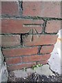
Ordnance Survey Cut Mark
This OS Cut Mark can be found on a brick pillar between No184 & No186 Heol-Y-Gors. It marks a point 171.4683m above mean sea level.
Image: © Adrian Dust
Taken: 29 Jun 2013
0.12 miles
3
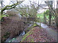
Pompren yng Nghwmgors / Footbridge at Cwmgors
Pompren yn rhychwantu nant yng Nghwmgors.
A footbridge spanning a stream at Cwmgors (trans. valley of marshy ground).
Image: © Alan Richards
Taken: 21 Feb 2020
0.13 miles
4
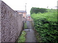
Llwybr Cwmgors / Cwmgors Path
Llwybr cyhoeddus yn cyrraedd yr A474 yng Nghwmgors.
A public footpath approaching the A474 at Cwmgors (trans. valley of marshy ground).
Image: © Alan Richards
Taken: 21 Feb 2020
0.13 miles
5
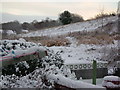
Old Cwmgors brick works site.
This is a photo from my garden of the site of the old Cwmgors brick works which is now an old people's complex and slag heap that has been reclaimed by nature.
Image: © Geraint Smith
Taken: 25 Nov 2005
0.18 miles
6
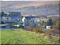
Llwyn Road , Cwmgors
The north facing back gardens of Llwyn Road.
Image: © Geraint Smith
Taken: 4 Nov 2006
0.18 miles
7
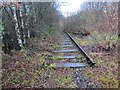
Hen reilffordd Cwmgors / Former Cwmgors railway
Gweddillion y rheilfordd yng Nghwmgors. Ychydig o'r traciau sydd ar ol.
The remains of the railway at Cwmgors (trans. valley of marshy ground). Most of the track has been removed.
Image: © Alan Richards
Taken: 21 Feb 2020
0.19 miles
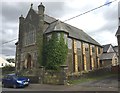
8
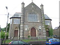
Capel Y Tabernacl
Grade II listed Welsh speaking chapel.
Image: © Jeremy Bolwell
Taken: 4 Jun 2012
0.19 miles
9
Capel y Tabernacl
Capel y Tabernacl, Cwmgors - a Grade II listed building.
Image: © Alan Hughes
Taken: 24 Aug 2017
0.19 miles
10
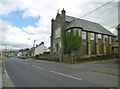
Cwmgors, Y Tabernacl
Disused chapel on Heol-y-Gors; looking very uncared-for.
Image: © Mike Faherty
Taken: 14 Jul 2016
0.19 miles