IMAGES TAKEN NEAR TO
Derwydd Avenue, AMMANFORD, SA18 1PH
Introduction
This page details the photographs taken nearby to Derwydd Avenue, SA18 1PH by members of the Geograph project.
The Geograph project started in 2005 with the aim of publishing, organising and preserving representative images for every square kilometre of Great Britain, Ireland and the Isle of Man.

There are currently over 7.5m images from over14,400 individuals and you can help contribute to the project by visiting https://www.geograph.org.uk
Image Map (Loading...)


Getting Data...Please wait
Leaflet Map data © OpenStreetMap
Images are licensed for reuse under creativecommons.org/licenses/by-sa/2.0
Notes
- Clicking on the map will re-center to the selected point.
- The higher the marker number, the further away the image location is from the centre of the postcode.
Image Listing (11 Images Found)
Images are licensed for reuse under creativecommons.org/licenses/by-sa/2.0
Image
Details
Distance
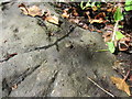
1
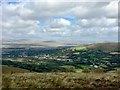
Gwaun-Cae-Gurwen
View down into the Upper Clydach valley from Bryn Mawr.
Image: © Alan Hughes
Taken: 5 Sep 2019
0.03 miles
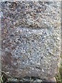
2
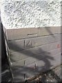
Ordnance Survey Cut Mark
This OS Cut Mark can be found on the front of No4 Heol Hir. It marks a point 164.1257m above mean sea level.
Image: © Adrian Dust
Taken: 29 Jun 2013
0.08 miles
3
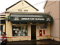
Gwaun Cae Gurwen: the post office
Looking through heavy rain at the frontage of the post office. Hyphens or spaces between the words of the placename seem equally acceptable.
Image: © Chris Downer
Taken: 21 Aug 2010
0.19 miles
4
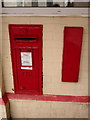
Gwaun Cae Gurwen: postbox № SA18 282
This George V-reign postbox is set into the wall of Image and is emptied finally at 5pm on weekdays and at 11am on Saturdays. Alongside is what I assume is a former stamp vending machine.
Image: © Chris Downer
Taken: 21 Aug 2010
0.19 miles
5
Ordnance Survey Rivet
This OS Rivet, with arrow, can be found on the parapet of the road bridge over Cwm Garnant in Gwaun-Cae-Gurwen. It marks a point 152.1287m above mean sea level.
Image: © Adrian Dust
Taken: 29 Jun 2013
0.19 miles
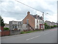
6
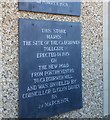
Turn-Pike Tollgate Plaque
This plaque can be found on the Funeral Directors east side of the road.
Image: © Adrian Dust
Taken: 14 May 2020
0.20 miles
7
Ordnance Survey Cut Mark
This OS cut mark can be found on the NW corner of Carmel Chapel. It marks a point 196.6143m above mean sea level. http://www.geograph.org.uk/photo/3751883
Image: © Adrian Dust
Taken: 21 Nov 2013
0.20 miles
8
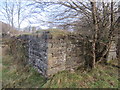
Carmel Chapel (Ruin)
There is an Ordnance Survey cut mark on this corner. http://www.geograph.org.uk/photo/3751848
Image: © Adrian Dust
Taken: 21 Nov 2013
0.20 miles
9
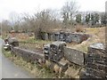
Capel Carmel Chapel, Gwauncaegurwen
Dyma weddillion Capel Carmel (Hen Garmel) yng Ngwauncaegurwen. Adeiladwyd y capel cyntaf yn 1762 ar ochr yr unig heol a fodolai y cyfnod hwnnw yn y pentre. Ailadeiladwyd y ty cwrdd yn 1825 ac eto yn 1829. Gyda thwf ym mhoblogaeth y pentre yn sgil suddo pyllau glo daeth yr hen gapel yn rhy fach ac felly yn 1877 codwyd capel newydd yng nghanol y gymuned. Er gwaetha'r faith i'r hen gapel gael ei adnewyddu yn 1929 fe'i dymwchwelyd flynynoedd yn ol ar ol i dân ei ddinistrio.
The remains of Carmel Old Chapel in Gwauncaegurwen. The first chapel was built in 1762 on what was, at that time, the only road in the village. The chapel was rebuilt in 1825 and again in 1829. With the sinking of collieries in the area the old meeting house was deemed too small to accommodate the new worshippers and a new chapel was built in 1877 at a more convenient location within the village. The old chapel, despite being renovated in 1929, was demolished several years ago after being destroyed by fire.
Image: © Alan Richards
Taken: 10 Apr 2013
0.21 miles
10
The old RAOB Club, Gwaun-Cae-Gurwen
The Royal Antediluvian Order of Buffaloes club has seen better days.
Image: © Jeremy Bolwell
Taken: 4 Jun 2012
0.23 miles