IMAGES TAKEN NEAR TO
Garnant, AMMANFORD, SA18 1NT
Introduction
This page details the photographs taken nearby to SA18 1NT by members of the Geograph project.
The Geograph project started in 2005 with the aim of publishing, organising and preserving representative images for every square kilometre of Great Britain, Ireland and the Isle of Man.

There are currently over 7.5m images from over14,400 individuals and you can help contribute to the project by visiting https://www.geograph.org.uk
Image Map
Images are licensed for reuse under creativecommons.org/licenses/by-sa/2.0
Notes
- Clicking on the map will re-center to the selected point.
- The higher the marker number, the further away the image location is from the centre of the postcode.
Image Listing (9 Images Found)
Images are licensed for reuse under creativecommons.org/licenses/by-sa/2.0
Image
Details
Distance
1
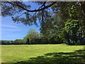
View across meadow
Meadowland near Pistyll Llwyd Isaf.
Image: © Alan Hughes
Taken: 15 May 2018
0.04 miles
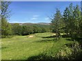
2
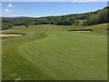
14th green at Garnant Golf Club
Looking back along the fairway from the 14th green at Garnant Golf Club.
Image: © Alan Hughes
Taken: 15 May 2018
0.05 miles
3
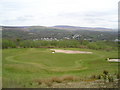
Parc Garnant Golf Course
Built on former opencast workings.
Image: © Marion Phillips
Taken: 27 Apr 2010
0.07 miles
4
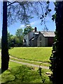
Gelli Caedrum Isaf
Smallholding adjacent to Garnant Golf Club.
Image: © Alan Hughes
Taken: 15 May 2018
0.08 miles
5
15th hole at Garnant Golf Club
View along the fairway of the 15th hole at Garnant Golf Club.
Image: © Alan Hughes
Taken: 15 May 2018
0.10 miles
6
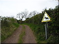
Moose crossing?
You might meet anything on this bridleway.
Image: © Marion Phillips
Taken: 27 Apr 2010
0.10 miles
8
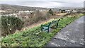
Bench, overlooking the Amman Valley
A bench in Ynys Dawela Nature Park overlooking the upper Amman Valley. The park was originally (like so many other open places in the area) a coal slag tip which was reduced in size and converted into the nature park that is there today.
Image: © Hywel Williams
Taken: 30 Jan 2022
0.25 miles
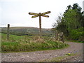
9

Llwybr Mynydd y Betws Path
Cerddwyr ar gyfordd o lwybrau a leolir ar lethrau Mynydd y Betws.
Walkers at a junction of paths located on the lower slopes of Betws Mountain (trans. beadhouse (i.e. prayer house).
Image: © Alan Richards
Taken: 30 Jan 2005
0.25 miles