IMAGES TAKEN NEAR TO
Bishop Road, AMMANFORD, SA18 1NA
Introduction
This page details the photographs taken nearby to Bishop Road, SA18 1NA by members of the Geograph project.
The Geograph project started in 2005 with the aim of publishing, organising and preserving representative images for every square kilometre of Great Britain, Ireland and the Isle of Man.

There are currently over 7.5m images from over14,400 individuals and you can help contribute to the project by visiting https://www.geograph.org.uk
Image Map (11 Images)


Getting Data...Please wait
Leaflet Map data © OpenStreetMap
Images are licensed for reuse under creativecommons.org/licenses/by-sa/2.0
Notes
- Clicking on the map will re-center to the selected point.
- The higher the marker number, the further away the image location is from the centre of the postcode.
Image Listing (11 Images Found)
Images are licensed for reuse under creativecommons.org/licenses/by-sa/2.0
Image
Details
Distance
1
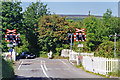
Crossing Amman Valley railway near site of Garnant station, 1994
View northward, across ex-GWR Pantyfynnon (to left) - (to right) Brynamman (West) branch, which closed to passengers 18/8/58, Garnant station having been about 200 yards to the left. The line was closed to freight officially in 1988 after closure Of Abernant Colliery, but in 1994 it was probably still in use by trains removing the vast stockpile of anthracite from Abernant. It was reopened in 2009 for bringing opencast coal from Tairgwaith and it seems that a passenger service may return under the auspices of the Swansea 9 Lines Movement. Behind is the Carmarthen Black Mountain range (Tair Carnisaf, 1,503 ft.).
Image: © Ben Brooksbank
Taken: 14 Jun 1994
0.13 miles
3
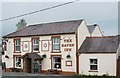
The Raven Inn, Garnant
This is a recreation of the old photo seen on the following page:
http://freepages.history.rootsweb.ancestry.com/~cwmgors/Garnant5.html http://web.archive.org/web/20111011222354/http://www.tytwp.plus.com/Waun/Garnant5.html
The chimneys are gone and the pub name is no longer painted on the window glass but on a swinging sign together with lettering on the wall. An entrance porch is also a more recent addition.
Image: © Nigel Davies
Taken: 11 Oct 2011
0.14 miles
4
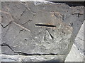
Ordnance Survey Cut Mark
This Ordnance Survey NBM Cut Mark can be found on the SE Angle, S Face of No 170 Cwmamman Road. 0.4m above ground level. It is 114.8860m above mean sea level.
Image: © Adrian Dust
Taken: 6 Jun 2013
0.16 miles
5
Y Palais, Garnant
Llwybr seiclo yn mynd heibio i hen safle Palais de Danse sef neuadd a agorwyd yn 1923 er cynnal dawnsfeydd, cyngerddau a ffilmiau. Yn ystod y 1950au a'r 1960au roedd y lle yn boblogaidd iawn gyda phobl ifanc yr ardal fel neuadd ddawnsio. Cyn cau bu'r adeilad hefyd yn ffatri jins a gweithdy ceir. Fe'i dymchwelwyd yn 2011 ac mae safle bellach yn faes parcio a safle bicnig.
A cycle track passing the site of the former Palais de Danse, a hall which opened in 1923 as a venue for dancing, concerts and for watching films. In its heyday during the 1950s and 60s the place was very popular with young people as a dance hall. Prior to its closure the building was also used as a jeans factory and as a car workshop. Demolished in 1911 the site is today a car park and a picnic site.
Image: © Alan Richards
Taken: 24 Apr 2014
0.17 miles
6
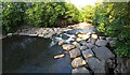
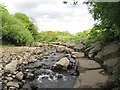
Weir on the Aman
Looking upstream from a viewing platform in Parc Golwg yr Aman.
Image: © Nigel Davies
Taken: 8 Jun 2013
0.18 miles
7
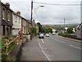
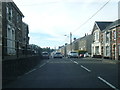
Garnant
Mining village high in Cwm Aman. On the edge of the coalfield with older limestones appearing at the surface nearby on the Black Mountain.
Image: © Richard Webb
Taken: 23 Jun 2006
0.19 miles
8
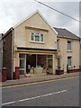
Head Quarters
Once a shop, now a hairdressers. Garnant.
Image: © Richard Webb
Taken: 23 Jun 2006
0.19 miles
9
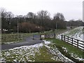
Reinforced bend in the Aman
The lamp post that is visible is on one of the more recently completed sections of the valley cycleway Image which is on the south bank of the river at this point.
Image: © Nigel Davies
Taken: 9 Jun 2013
0.19 miles
10
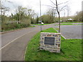
Cycle track
A recently built cycle path along the first stretches of a dismantled railway branch that ran from the Amman Valley railway. Although labelled as a Sustrans route, it doesn't appear to have a route number. As a paved route, it's only a couple of hundred yards long and a logicial extension further east to Brynamman along the rail route is barred by a sign stating that there's no public right of way.
Image: © Hywel Williams
Taken: 10 Feb 2007
0.21 miles