IMAGES TAKEN NEAR TO
Garnant, AMMANFORD, SA18 1JU
Introduction
This page details the photographs taken nearby to SA18 1JU by members of the Geograph project.
The Geograph project started in 2005 with the aim of publishing, organising and preserving representative images for every square kilometre of Great Britain, Ireland and the Isle of Man.

There are currently over 7.5m images from over14,400 individuals and you can help contribute to the project by visiting https://www.geograph.org.uk
Image Map (Loading...)


Getting Data...Please wait
Leaflet Map data © OpenStreetMap
Images are licensed for reuse under creativecommons.org/licenses/by-sa/2.0
Notes
- Clicking on the map will re-center to the selected point.
- The higher the marker number, the further away the image location is from the centre of the postcode.
Image Listing (11 Images Found)
Images are licensed for reuse under creativecommons.org/licenses/by-sa/2.0
Image
Details
Distance
1
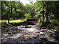
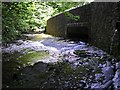
Bridge over the Nant Pedol
A new bridge built in 2000 to replace a ford. The water is brown and peaty and there is plenty of it flowing off the mountain after a wet July.
Image: © Marion Phillips
Taken: 27 Jul 2009
0.01 miles
2
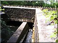
Gwinau Bridge
There used to be a ford here, but in 2000 this bridge was built as part of the Pedol and Gwinau Bridges Improvement project. On the left there is a weir and on the right a fish ladder, a less steep stepped arrangement of pools to allow fish to swim upstream to spawn.
Image: © Marion Phillips
Taken: 27 Jul 2009
0.03 miles
3
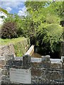
Bridge over Nant Pedol
The plaque records that improvements have recently been made to this bridge.
Image: © Alan Hughes
Taken: 4 May 2020
0.03 miles
4
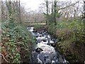
Nant Pedol at Brynarfon
My camera is still on British Summer Time so it may appear that I took this photo after it was submitted
Image: © Sandy Gerrard
Taken: 25 Dec 2022
0.03 miles
5
Pedol and Gwinau Bridges Improvement, Garnant
In 2000 bridges were built to replace fords where the road crossed these two streams. In the photograph the Gwinau is flowing under the road and joining the dark swirling waters of the Pedol.
Image: © Marion Phillips
Taken: 27 Jul 2009
0.04 miles
6
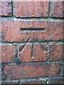
Ordnance Survey Cut Mark
This OS Cut Mark can be found on a brick wall to the North of Llandeilo Road. It marks a point 129.2624m above mean sea level.
Image: © Adrian Dust
Taken: 4 Jul 2013
0.06 miles
7
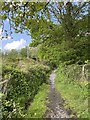
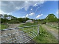
Country lane
The track leads up Cwm Pedol.
Image: © Alan Hughes
Taken: 4 May 2020
0.09 miles
10
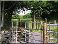
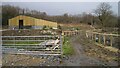
Footpath junction
Three footpaths diverging from the dead end of this road.
Image: © Marion Phillips
Taken: 6 Jul 2010
0.20 miles