IMAGES TAKEN NEAR TO
Maesywern Road, AMMANFORD, SA18 1HX
Introduction
This page details the photographs taken nearby to Maesywern Road, SA18 1HX by members of the Geograph project.
The Geograph project started in 2005 with the aim of publishing, organising and preserving representative images for every square kilometre of Great Britain, Ireland and the Isle of Man.

There are currently over 7.5m images from over14,400 individuals and you can help contribute to the project by visiting https://www.geograph.org.uk
Image Map (Loading...)


Getting Data...Please wait
Leaflet Map data © OpenStreetMap
Images are licensed for reuse under creativecommons.org/licenses/by-sa/2.0
Notes
- Clicking on the map will re-center to the selected point.
- The higher the marker number, the further away the image location is from the centre of the postcode.
Image Listing (9 Images Found)
Images are licensed for reuse under creativecommons.org/licenses/by-sa/2.0
Image
Details
Distance
2
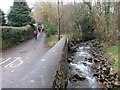
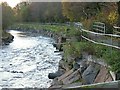
Afon Garenig River
Afon Garenig yn llifo'n gyfochrog â heol yng Nghlanaman.
The Garenig River flows parallel with a minor road in Glanaman.
Image: © Alan Richards
Taken: 23 Feb 2014
0.16 miles
3
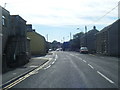
Railway Crossing in Glanaman
A small un-gated railway crossing on a railway that runs up the Amman Valley. The railway was recently refurbished for 1 Million Pounds and has allegedly had the sum total of one train run up and down the line in the last year.
Image: © Hywel Williams
Taken: 6 Jul 2008
0.16 miles
4
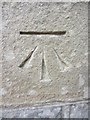
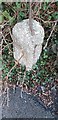
Ordnance Survey Cut Mark
This Ordnance Survey Cut Mark can be found on the front of No 128 Cwmamman Road. It marks a point 86.2520m above mean sea level.
Image: © Adrian Dust
Taken: 20 Jun 2013
0.20 miles
5
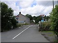
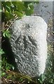
Old Milestone by the A474 in Glanaman
This old milestone is on the north side of the A474 Cwmamman Road in Glanaman, almost opposite Llwyncelyn Road. Interestingly old-maps show the MS further east near #186 Cwmamman Road so it must have been moved at some time. The rivet bench mark confirms that it is almost certainly the same stone.
Inscription once read:- : (Llandilo 10 / Neath 14) :
Carved bench mark and rivet on top.
Milestone Society National ID: CAM_LONE10
Image: © Kirstie Hackett
Taken: 28 Jan 2020
0.20 miles
6
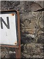
Milestone - Llandeilo 10
Very worn granite block which is probably a relocated milestone which was once a short distance to the east. The damaged OS benchmark would have marked a point 280.3ft above mean sea level.
Image: © Adrian Dust
Taken: 14 Sep 2020
0.20 miles
7
Ordnance Survey Cut Mark
This Ordnance Survey Cut Mark can be found on the roadside wall of No 1 Maes Ywern. It marks a point 112.2153m above mean sea level. It also seems to be up-side-down!
Image: © Adrian Dust
Taken: 20 Jun 2013
0.21 miles
8
Ordnance Survey Rivet
This Ordnance Survey Rivet can be found on a concrete culvert on the SW side of the road. It marks a point 96.3686m above mean sea level.
Image: © Adrian Dust
Taken: 20 Jun 2013
0.21 miles
9
Amman Valley Cyclepath crosses Nant Coch
The new cycle path on the north bank of the River Amman crosses the tiny tributary Nant Coch on a small bridge with railings.
Image: © Nigel Davies
Taken: 14 Nov 2010
0.23 miles