IMAGES TAKEN NEAR TO
Upper Colbren Road, AMMANFORD, SA18 1HR
Introduction
This page details the photographs taken nearby to Upper Colbren Road, SA18 1HR by members of the Geograph project.
The Geograph project started in 2005 with the aim of publishing, organising and preserving representative images for every square kilometre of Great Britain, Ireland and the Isle of Man.

There are currently over 7.5m images from over14,400 individuals and you can help contribute to the project by visiting https://www.geograph.org.uk
Image Map
Images are licensed for reuse under creativecommons.org/licenses/by-sa/2.0
Notes
- Clicking on the map will re-center to the selected point.
- The higher the marker number, the further away the image location is from the centre of the postcode.
Image Listing (17 Images Found)
Images are licensed for reuse under creativecommons.org/licenses/by-sa/2.0
Image
Details
Distance
1
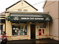
Gwaun Cae Gurwen: the post office
Looking through heavy rain at the frontage of the post office. Hyphens or spaces between the words of the placename seem equally acceptable.
Image: © Chris Downer
Taken: 21 Aug 2010
0.08 miles
2
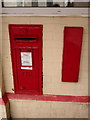
Gwaun Cae Gurwen: postbox № SA18 282
This George V-reign postbox is set into the wall of Image and is emptied finally at 5pm on weekdays and at 11am on Saturdays. Alongside is what I assume is a former stamp vending machine.
Image: © Chris Downer
Taken: 21 Aug 2010
0.08 miles
3
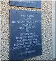
Turn-Pike Tollgate Plaque
This plaque can be found on the Funeral Directors east side of the road.
Image: © Adrian Dust
Taken: 14 May 2020
0.11 miles
4
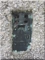
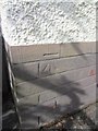
Ordnance Survey Flush Bracket
This Ordnance Survey Flush Bracket (S1239) can be found on the side of No103 Heol-Cae-Gurwen. It marks a point 155.0750m above mean sea level.
Image: © Adrian Dust
Taken: 1 Jun 2013
0.11 miles
5
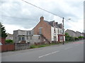
The old RAOB Club, Gwaun-Cae-Gurwen
The Royal Antediluvian Order of Buffaloes club has seen better days.
Image: © Jeremy Bolwell
Taken: 4 Jun 2012
0.11 miles
6
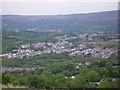
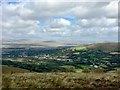
Gwaun-Cae-Gurwen
The village of Gwaun-Cae-Gurwen from Mynydd Uchaf.
Image: © Geraint Smith
Taken: 17 May 2008
0.13 miles
9
Gwaun-Cae-Gurwen
View down into the Upper Clydach valley from Bryn Mawr.
Image: © Alan Hughes
Taken: 5 Sep 2019
0.16 miles
10
Ordnance Survey Cut Mark
This OS Cut Mark can be found on the front of No4 Heol Hir. It marks a point 164.1257m above mean sea level.
Image: © Adrian Dust
Taken: 29 Jun 2013
0.18 miles