IMAGES TAKEN NEAR TO
Gwaun Cae Gurwen, AMMANFORD, SA18 1DT
Introduction
This page details the photographs taken nearby to SA18 1DT by members of the Geograph project.
The Geograph project started in 2005 with the aim of publishing, organising and preserving representative images for every square kilometre of Great Britain, Ireland and the Isle of Man.

There are currently over 7.5m images from over14,400 individuals and you can help contribute to the project by visiting https://www.geograph.org.uk
Image Map (Loading...)


Getting Data...Please wait
Leaflet Map data © OpenStreetMap
Images are licensed for reuse under creativecommons.org/licenses/by-sa/2.0
Notes
- Clicking on the map will re-center to the selected point.
- The higher the marker number, the further away the image location is from the centre of the postcode.
Image Listing (28 Images Found)
Images are licensed for reuse under creativecommons.org/licenses/by-sa/2.0
Image
Details
Distance
1
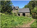
Farm buildings
Farm buildings on the banks of Cwm Garnant.
Image: © Alan Hughes
Taken: 15 May 2018
0.01 miles
2
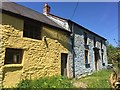
Colourful farm buildings
A fresh coat of paint makes these remote farm buildings look very appealing in the early summer sunshine. Located above the Garnant valley near Gwaun-Cae-Gurwen.
Image: © Alan Hughes
Taken: 15 May 2018
0.01 miles
3
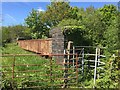
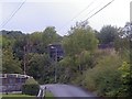
Kissing gate and railway bridge
The dismantled railway used to run along the Garnant valley through Cwmgors, meeting the Amman valley line near the level crossing at Gwaun-Cae-Gurwen.
Image: © Alan Hughes
Taken: 15 May 2018
0.03 miles
4
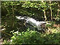
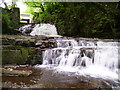
Garnant waterfall
A small waterfall in a pretty, woodland glade in the Garnant valley at Gwaun-Cae-Gurwen.
Image: © Alan Hughes
Taken: 15 May 2018
0.04 miles
5
Gwaun-Cae-Gurwen falls
The Garnant river at the Waun falls at Pwll y Wrach. Notice the ruins of the old mill on the top left hand side of the photo.
Image: © Geraint Smith
Taken: 17 May 2008
0.06 miles
6
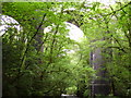
Railway Bridge, through trees
This bridge formed part of the branch line that went from Gwaun Cae Gurwen to Abernant Collieries. Two bridges were built to serve each direction but amazingly only the down-valley junction bridge was ever used - no tracks were laid on this bridge and the land just beyond the viaduct has since been taken over as a private garden.
Image: © Hywel Williams
Taken: 24 Aug 2003
0.07 miles
7
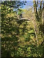
Viaduct at Gwaun-Cae-Gurwen
Viaduct over Cwm Garnant at Gwaun-Cae-Gurwen.
Image: © Alan Hughes
Taken: 15 May 2018
0.09 miles
8
Gwaun-Cae-Gurwen viaducts
The 2 viaducts at Gwaun-Cae-Gurwen, used to transport coal from the Gwaun-Cae-Gurwen and Tairgwaith mines down to Ammanford and beyond. I believe the upper (nearest) was never used. The lower viaduct (furthest) will soon be used again when the opencast mine is to re-open at Tairgwaith.
Image: © Geraint Smith
Taken: 17 May 2008
0.10 miles
9
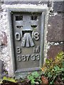
Ordnance Survey Flush Bracket
This Ordnance Survey Flush Bracket (S8793) can be found on the parapet of the Viaduct which heads South West from this point. It marks a point 157.0750m above mean sea level.
Image: © Adrian Dust
Taken: 1 Jun 2013
0.10 miles
10
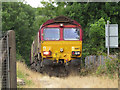
Freight train at Gwaun-cae-Gurwen
Class 66 No. 66187 approaches the level crossing at Gwaun-cae-Gurwen with a train of empty coal wagons from Swansea Burrows.
Image: © Gareth James
Taken: 12 Jul 2018
0.11 miles