IMAGES TAKEN NEAR TO
Llandeilo Road, AMMANFORD, SA18 1BW
Introduction
This page details the photographs taken nearby to Llandeilo Road, SA18 1BW by members of the Geograph project.
The Geograph project started in 2005 with the aim of publishing, organising and preserving representative images for every square kilometre of Great Britain, Ireland and the Isle of Man.

There are currently over 7.5m images from over14,400 individuals and you can help contribute to the project by visiting https://www.geograph.org.uk
Image Map (Loading...)


Getting Data...Please wait
Leaflet Map data © OpenStreetMap
Images are licensed for reuse under creativecommons.org/licenses/by-sa/2.0
Notes
- Clicking on the map will re-center to the selected point.
- The higher the marker number, the further away the image location is from the centre of the postcode.
Image Listing (4 Images Found)
Images are licensed for reuse under creativecommons.org/licenses/by-sa/2.0
Image
Details
Distance
1
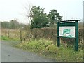
North entrance to Parc Ynys Dawela
A woodland park has been created on a former colliery here on the north bank of the river Amman. This is the north access point on a mountain road. The finger post points down a lane that it must be possible to drive down, since there is a parking area deeper in the park.
Image: © Nigel Davies
Taken: 7 Jan 2006
0.07 miles
2
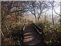
Llwybr Ynys Dawela Footpath
Llwybr ym Mharc Natur Ynys Dawela. Yn wreiddiol ffermiwyd y parc gan Ffarm Ynys Dawela ac yn ystod y bedwaredd ganrif ar bymtheg fe agorwyd pwll glo o'r un enw ar y safle a lle bu caeau glesion cafwyd tomenni duon. Heddiw, trawsnewidiwyd y ardal yn llwyr drwy blannu coed collddail a chreu llwybrau newydd.
A footpath at Ynys Dawela Nature Reserve. Originally, the land was toiled by Ynys Dawela Farm but during the nineteenth century a colliery was sunk and the once green fields and hedges were replaced by black waste tips. Today, the tips have gone and there has been a total transformation with the planting of deciduous trees and the creation of new footpaths.
Image: © Alan Richards
Taken: 5 Dec 2010
0.21 miles
3
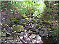
Nant Gwinau
It is July and there is not much water in the stream at the moment, but the rounded boulders show that sometimes a great deal of water comes down off the moors.
Image: © Marion Phillips
Taken: 6 Jul 2010
0.21 miles
4
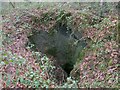
Abandoned Coal Pit at Ynys Dawela Park
The nearby information board describes how local farms' own small scale mining efforts were overtaken by a mining revolution. This pit was part of the Ynys Amman colliery by 1921.
Now it if fenced off for safety in an overgrown woodland. The pit head here would once have had a railway link south over the river, joining the main valley line.
Image: © Nigel Davies
Taken: 22 Jan 2012
0.24 miles