IMAGES TAKEN NEAR TO
Cwmgarw Road, AMMANFORD, SA18 1BU
Introduction
This page details the photographs taken nearby to Cwmgarw Road, SA18 1BU by members of the Geograph project.
The Geograph project started in 2005 with the aim of publishing, organising and preserving representative images for every square kilometre of Great Britain, Ireland and the Isle of Man.

There are currently over 7.5m images from over14,400 individuals and you can help contribute to the project by visiting https://www.geograph.org.uk
Image Map
Images are licensed for reuse under creativecommons.org/licenses/by-sa/2.0
Notes
- Clicking on the map will re-center to the selected point.
- The higher the marker number, the further away the image location is from the centre of the postcode.
Image Listing (26 Images Found)
Images are licensed for reuse under creativecommons.org/licenses/by-sa/2.0
Image
Details
Distance
1
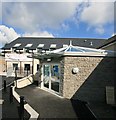
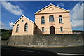
Black Mountain Centre in Brynamman
Black Mountain Centre aka Canolfan Gymunedol Brynamman Community Centre, situated in the former Infants' School.
Photo courtesy of the Aberdare Blog Gallery http://www.aberdareblog.co.uk/ which contains many more Brynamman photos.
Image: © Darren W Rees
Taken: 26 Jul 2008
0.02 miles
2
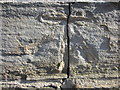
Ordnance Survey Cut Mark
This slightly damaged OS Cut Mark can be found on the front of No 50 Cwmgarw Road. It marks a point 183.6012m above mean sea level.
Image: © Adrian Dust
Taken: 7 Jul 2013
0.05 miles
3
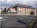
Black Mountain Centre
The old school which functioned for a few years as Brynaman Community Centre has now been extended and re-launched as the Black Mountain Centre - worth a visit if you're in the area for good food in the cafe/restaurant.
Image: © Alan Bowring
Taken: 1 Oct 2008
0.09 miles
5
Heol y Mynydd
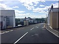
The Mountain Road, A4069, rising out of Brynaman.
Image: © Alan Hughes
Taken: 15 Aug 2019
0.11 miles
6
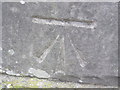
Ordnance Survey Cut Mark
This OS Cut Mark can be found on the west face of what was the Brynamman Infants School. It marks a point 184.0160m above mean sea level.
Image: © Adrian Dust
Taken: 4 Jul 2013
0.11 miles
7
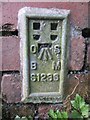
Ordnance Survey Cut Mark
This OS Cut Mark can be found on the front of No24 Mountain Road. It marks a point 193.1268m above mean sea level.
Image: © Adrian Dust
Taken: 4 Jul 2013
0.11 miles
8
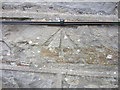
Ordnance Survey Flush bracket
This OS Flush Bracket can be found on the side of an old garage on the West side of Mountain Road. It marks a point 193.5675m above mean sea level.
Image: © Adrian Dust
Taken: 1 Jun 2013
0.12 miles
9
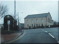
Gibea Chapel, Brynamman
Gibea Chapel, Brynamman.
Image: © Darren W Rees
Taken: 26 Jul 2008
0.12 miles
10
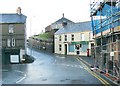
Brynamman Post Office (Recreated)
This is a recreation of the following 1955 photo from the Frith collection: http://www.francisfrith.com/search/wales/dyfed/brynamman/photos/brynamman_B471009.htm
Apart from the building in the foreground on the left edge having gone, most of the other features remain.
The loss of the building has allowed the tight corner to improve. The bridge wall on the right has been moved further out to widen the road and pavement and the phone box has gone to allow the cutting of a new pavement up the hill in the distance.
Image: © Nigel Davies
Taken: 6 Jan 2007
0.15 miles