IMAGES TAKEN NEAR TO
Blaencefn, SWANSEA, SA1 7LF
Introduction
This page details the photographs taken nearby to Blaencefn, SA1 7LF by members of the Geograph project.
The Geograph project started in 2005 with the aim of publishing, organising and preserving representative images for every square kilometre of Great Britain, Ireland and the Isle of Man.

There are currently over 7.5m images from over14,400 individuals and you can help contribute to the project by visiting https://www.geograph.org.uk
Image Map (Loading...)


Getting Data...Please wait
Leaflet Map data © OpenStreetMap
Images are licensed for reuse under creativecommons.org/licenses/by-sa/2.0
Notes
- Clicking on the map will re-center to the selected point.
- The higher the marker number, the further away the image location is from the centre of the postcode.
Image Listing (6 Images Found)
Images are licensed for reuse under creativecommons.org/licenses/by-sa/2.0
Image
Details
Distance
2
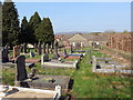
Mynwent Carmel / Carmel burial ground
Mynwent Capel Carmel, addoldy'r Methodistiaid Calfinaidd.
Burial ground of Carmel Calvinistic Methodist Chapel.
Image: © Alan Richards
Taken: 1 Apr 2019
0.07 miles
3
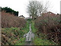
Llwybr Pentre Dwr/ Pentre Dwr Path
Llwybr cyhoeddus yn agosau at yr hewl ym Mhentre Dwr.
A public footpath approaching the road at Pentre Dwr (trans. water farm / village).
Image: © Alan Richards
Taken: 27 Feb 2017
0.11 miles
4
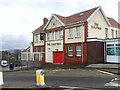
The Halfway
Halfway between Bonymaen and Trallwn is ... The Halfway.
Image: © Alan Hughes
Taken: 21 Jan 2019
0.16 miles
5
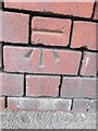
Ordnance Survey Cut Mark
This OS cut mark can be found on the Halfway Inn. It marks a point 67.657m above mean sea level.
Image: © Adrian Dust
Taken: 6 May 2014
0.17 miles
6
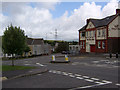
The Halfway Inn near Winsh-wen, Swansea
This pub, between Pentre-dwr, Trallwn and Winsh-wen, sits at a "saddle" in the ridge separating the Swansea Valley from Crymlyn Bog and near the summit of roads leading up from each of these locations. Situated beside a former main road from Neath to Swansea, it is to the distance between these two towns that the "halfway" probably refers.
Image: © Kevin Flynn
Taken: 1 Aug 2008
0.18 miles