IMAGES TAKEN NEAR TO
Phoebe Road, SWANSEA, SA1 7GA
Introduction
This page details the photographs taken nearby to Phoebe Road, SA1 7GA by members of the Geograph project.
The Geograph project started in 2005 with the aim of publishing, organising and preserving representative images for every square kilometre of Great Britain, Ireland and the Isle of Man.

There are currently over 7.5m images from over14,400 individuals and you can help contribute to the project by visiting https://www.geograph.org.uk
Image Map
Images are licensed for reuse under creativecommons.org/licenses/by-sa/2.0
Notes
- Clicking on the map will re-center to the selected point.
- The higher the marker number, the further away the image location is from the centre of the postcode.
Image Listing (36 Images Found)
Images are licensed for reuse under creativecommons.org/licenses/by-sa/2.0
Image
Details
Distance
1
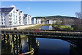
Rickety bridge over the River Tawe
The bridge is no longer in use, and you are not allowed to sail boats under it. Kilvey Hill is on the skyline.
Image: © Bill Boaden
Taken: 5 Apr 2016
0.03 miles
2
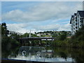
Bascule Bridge, Swansea
This historic bridge as seen from the River Tawe is one of the few surviving relics of the area's rich copper heritage. It had a water-powered lever system enabling a section of the bridge to be lifted to allow sailing ships to pass through.
It is due to be restored for cyclists and pedestrians to use.
Image: © Steve Barnes
Taken: 13 Aug 2016
0.04 miles
3
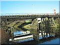
Pont Reilfordd y Morfa Railway Bridge
The Morfa railway bridge spanning the Tawe River and located near the Liberty Stadium, Swansea. Constructed in 1909 it carried waste from the Morfa Copper Works to a dump on the eastern side of the river. It also linked the former with the Upper Bank Copper Works. The bridge had a water tank on its western end which, when filled, enabled it to tilt up an allow high masted boats to pass through safely.
Rhychwanta Pont Reilffordd y Morfa Afon Tawe ger y Stadiwm Liberty. Adeiladwyd y bont yn 1909 er cludo gwastraff i'r tip ar ochr ddwyreinol o'r afon. Cysylltai'r rheilffordd hefyd y gwaith hwn a Gwaith Copr Upper Bank. Mae gan y bont danc dwr ar ei ochr orllewinol ac wrth i ddwr ei lenwi fe godai'r bont gan adael i fadau a hwyliau uchel basio heibio yn ddiogel.
Image: © Alan Richards
Taken: 28 Dec 2008
0.05 miles
4
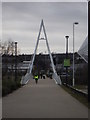
Swansea : Footbridge
A pedestrian path across the River Tawe.
Image: © Lewis Clarke
Taken: 1 Mar 2014
0.06 miles
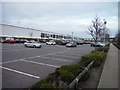
5
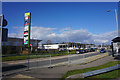
Morfa Shopping Park
A fairly new retail park off Brunel Way.
Image: © Bill Boaden
Taken: 5 Apr 2016
0.07 miles
6
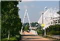
The pedestrian boulevard at Morfa Retail Park
The large structure on the right is the Liberty Stadium.
Image: © john bristow
Taken: 26 Aug 2013
0.08 miles
7
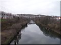
Swansea : River Tawe
From the footbridge looking down towards the River Tawe.
Image: © Lewis Clarke
Taken: 1 Mar 2014
0.08 miles
8
Swansea : The Liberty Stadium
Home of the Premier League's Swansea City Football Club.
Image: © Lewis Clarke
Taken: 1 Mar 2014
0.11 miles
9
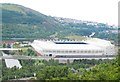
New Morfa Stadium
Swansea's new Football & Rugby 'Liberty Stadium' next to the River Tawe, near the Morfa retail park.
Image: © Nigel Davies
Taken: 31 Jul 2005
0.12 miles
10
Swansea : Morfa Retail Park
Morfa Retail Park outside of Swansea city centre.
Image: © Lewis Clarke
Taken: 1 Mar 2014
0.12 miles