IMAGES TAKEN NEAR TO
Cardigan Crescent, SWANSEA, SA1 7DY
Introduction
This page details the photographs taken nearby to Cardigan Crescent, SA1 7DY by members of the Geograph project.
The Geograph project started in 2005 with the aim of publishing, organising and preserving representative images for every square kilometre of Great Britain, Ireland and the Isle of Man.

There are currently over 7.5m images from over14,400 individuals and you can help contribute to the project by visiting https://www.geograph.org.uk
Image Map
Images are licensed for reuse under creativecommons.org/licenses/by-sa/2.0
Notes
- Clicking on the map will re-center to the selected point.
- The higher the marker number, the further away the image location is from the centre of the postcode.
Image Listing (6 Images Found)
Images are licensed for reuse under creativecommons.org/licenses/by-sa/2.0
Image
Details
Distance

2
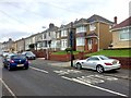
Mansel Road
Housing in Mansel Road, Bonymaen.
Image: © Alan Hughes
Taken: 21 Jan 2019
0.11 miles
3
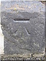
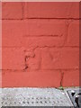
Ordnance Survey Cut Mark
This OS cut mark can be found on the wall post between No304 & No306 Jersey Road. It marks a point 57.735m above mean sea level.
Image: © Adrian Dust
Taken: 1 Sep 2015
0.15 miles
4
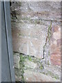
Ordnance Survey Cut Mark
This OS cut mark can be found on the wall of No364 Jersey Road. It marks a point 55.623m above mean sea level.
Image: © Adrian Dust
Taken: 1 Sep 2015
0.18 miles
5
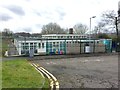
Welsh School in Bonymaen
Ysgol Gynradd Gymraeg y Cwm.
Image: © Alan Hughes
Taken: 21 Jan 2019
0.20 miles
6
Ordnance Survey Cut Mark
This OS cut mark can be found on the north angle of Eastside District Housing Office. It marks a point 62.603m above mean sea level.
Image: © Adrian Dust
Taken: 1 Sep 2015
0.21 miles