IMAGES TAKEN NEAR TO
Dartford Drive, SWANSEA, SA1 7DU
Introduction
This page details the photographs taken nearby to Dartford Drive, SA1 7DU by members of the Geograph project.
The Geograph project started in 2005 with the aim of publishing, organising and preserving representative images for every square kilometre of Great Britain, Ireland and the Isle of Man.

There are currently over 7.5m images from over14,400 individuals and you can help contribute to the project by visiting https://www.geograph.org.uk
Image Map
Images are licensed for reuse under creativecommons.org/licenses/by-sa/2.0
Notes
- Clicking on the map will re-center to the selected point.
- The higher the marker number, the further away the image location is from the centre of the postcode.
Image Listing (4 Images Found)
Images are licensed for reuse under creativecommons.org/licenses/by-sa/2.0
Image
Details
Distance
1
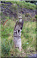
Dragon watch
This carved wooden dragon keeps a watchful eye on all those entering the Swansea suburb of Bon-y-maen.
Originally the centrepiece of a double-seated bench, the dragon -- commissioned by the local community -- was created by the chainsaw sculptor Nansi Hemming in 2002.
My thanks to Nigel Davies for the additional information.
Image: © Kevin Flynn
Taken: 1 Aug 2008
0.07 miles
2
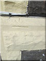
Ordnance Survey Cut Mark
This OS cut mark can be found on No5 Jersey Road. It marks a point 58.342m above mean sea level.
Image: © Adrian Dust
Taken: 1 Sep 2015
0.08 miles
3
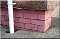
Ordnance Survey Cut Mark
This OS cut mark can be found on No229 Bon-y-maen Road. It marks a point 68.422m above mean sea level.
Image: © Adrian Dust
Taken: 22 Oct 2020
0.14 miles
4
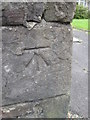
Ordnance Survey Cut Mark
This OS cut mark can be found on the wall of No52 Jersey Road. It marks a point 67.748m above mean sea level.
Image: © Adrian Dust
Taken: 1 Sep 2015
0.20 miles