IMAGES TAKEN NEAR TO
Viking Way, SWANSEA, SA1 7DE
Introduction
This page details the photographs taken nearby to Viking Way, SA1 7DE by members of the Geograph project.
The Geograph project started in 2005 with the aim of publishing, organising and preserving representative images for every square kilometre of Great Britain, Ireland and the Isle of Man.

There are currently over 7.5m images from over14,400 individuals and you can help contribute to the project by visiting https://www.geograph.org.uk
Image Map (Loading...)


Getting Data...Please wait
Leaflet Map data © OpenStreetMap
Images are licensed for reuse under creativecommons.org/licenses/by-sa/2.0
Notes
- Clicking on the map will re-center to the selected point.
- The higher the marker number, the further away the image location is from the centre of the postcode.
Image Listing (3 Images Found)
Images are licensed for reuse under creativecommons.org/licenses/by-sa/2.0
Image
Details
Distance
1
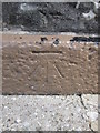
Ordnance Survey Cut Mark
This OS cut mark can be found on the front of the Colliers Arms. It marks a point 35.522m above mean sea level.
Image: © Adrian Dust
Taken: 1 Sep 2015
0.21 miles
2
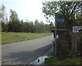
Former entrance to the Swansea Vale Railway on Jersey Road, Swansea
This 1998 view shows the former entrance to the preserved line run by the Swansea Vale Railway Society. The incline used to lead to the SVR's Six Pit Station. A double track viaduct used to continue from an abutment on the right hand side and continue across the road towards Llansamlet.
This line originally opened as part of the Swansea Vale Railway in the 1870s. It was taken over by the Midland Railway in 1876 and additional through routes were added as a result. Passenger services ceased in 1950 and complete closure took place in the 1960s. By 1985 the only railway here was the section preserved by the SVR Society. In 2007, Swansea Council decided to redevelop the area and by 2010 the preserved railway was itself history, although the society itself lives on.
Image: © vectorkraft
Taken: 8 May 1998
0.24 miles
3
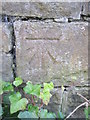
Ordnance Survey Cut Mark
This OS cut mark can be found on the wall on the SW side of the road. It marks a point 15.661m above mean sea level.
Image: © Adrian Dust
Taken: 1 Sep 2015
0.25 miles