IMAGES TAKEN NEAR TO
Tydraw Crescent, SWANSEA, SA1 7AZ
Introduction
This page details the photographs taken nearby to Tydraw Crescent, SA1 7AZ by members of the Geograph project.
The Geograph project started in 2005 with the aim of publishing, organising and preserving representative images for every square kilometre of Great Britain, Ireland and the Isle of Man.

There are currently over 7.5m images from over14,400 individuals and you can help contribute to the project by visiting https://www.geograph.org.uk
Image Map
Images are licensed for reuse under creativecommons.org/licenses/by-sa/2.0
Notes
- Clicking on the map will re-center to the selected point.
- The higher the marker number, the further away the image location is from the centre of the postcode.
Image Listing (9 Images Found)
Images are licensed for reuse under creativecommons.org/licenses/by-sa/2.0
Image
Details
Distance
1
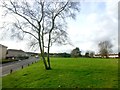
Open space
Field alongside Ty Draw Crescent, Bonymaen.
Image: © Alan Hughes
Taken: 21 Jan 2019
0.03 miles
2
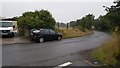
Swansea : Ty-Draw Road
A road heading out of the settlement.
Image: © Lewis Clarke
Taken: 15 Jul 2017
0.07 miles
3
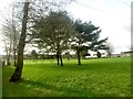
Recreation ground
Bonymaen recreation ground.
Image: © Alan Hughes
Taken: 21 Jan 2019
0.09 miles
4
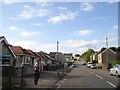
Mansel Road, Bon-y-maen
Houses and bungalows in a residential suburb
Image: © David Smith
Taken: 2 Jun 2018
0.17 miles
5
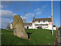
Standing Stone in Bonymaen
This standing stone lies incongruously just off the road in a busy housing estate.
Image: © Dave Farmer
Taken: 8 Jan 2005
0.19 miles
6
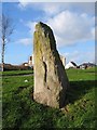
Standing Stone at Bonymaen
The purpose of this standing stone is not known, but it lies close to the route take by a Roman road from Loughor, crossing the River Tawe near here. It may have been a route marker.
Image: © Dave Farmer
Taken: 8 Jan 2005
0.19 miles
7
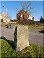
Bronze Age Standing Stone
1.3m high with base 1.2m x 0.5m.
Image: © Adrian Dust
Taken: 13 Feb 2023
0.23 miles
8
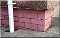
Ordnance Survey Cut Mark
This OS cut mark can be found on No229 Bon-y-maen Road. It marks a point 68.422m above mean sea level.
Image: © Adrian Dust
Taken: 22 Oct 2020
0.23 miles
9
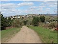
Bonymaen
Trac yn arwain i lawr o Fynydd Cilfai at Fonymaen. Cefn hengoed yw enw'r gefnen a'r pentre yn y pellter - man geni y Parchedig W. Samlet Williams, awdur Hanes Llansamlet a sawl cyhoeddiad arall.
Track leading down from Kilvey Hill towards Bonymaen. The ridge and settlement in the distance is called Cefn Hengoed - birthplace of the Reverend W. Samlet Williams, author of Hanes Llansamlet (History of Llansamlet) and other publications.
Image: © Alan Richards
Taken: 30 Apr 2013
0.24 miles