IMAGES TAKEN NEAR TO
FERRYSIDE, SA17 5YN
Introduction
This page details the photographs taken nearby to SA17 5YN by members of the Geograph project.
The Geograph project started in 2005 with the aim of publishing, organising and preserving representative images for every square kilometre of Great Britain, Ireland and the Isle of Man.

There are currently over 7.5m images from over14,400 individuals and you can help contribute to the project by visiting https://www.geograph.org.uk
Image Map (Loading...)


Getting Data...Please wait
Leaflet Map data © OpenStreetMap
Images are licensed for reuse under creativecommons.org/licenses/by-sa/2.0
Notes
- Clicking on the map will re-center to the selected point.
- The higher the marker number, the further away the image location is from the centre of the postcode.
Image Listing (7 Images Found)
Images are licensed for reuse under creativecommons.org/licenses/by-sa/2.0
Image
Details
Distance
1
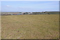
Farm buildings at Numpwell
Farmland and farm buildings at Numpwell near Llansaint.
Image: © Philip Halling
Taken: 6 Apr 2013
0.16 miles
2
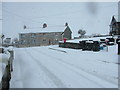
Pen y banc, Broadway
Broadway is a hamlet about 1/2 a mile from the village of Llansaint.
Image: © Frankie Owen-Pavitt
Taken: 9 Feb 2007
0.16 miles
3

Ordnance Survey Cut Mark
This OS cut mark can be found on the gatepost of no1 Pen-y-banc. It marks a point 105.183m above mean sea level.
Image: © Adrian Dust
Taken: 18 Jan 2022
0.18 miles
4
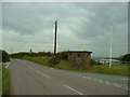
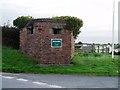
Defender of the crossroads
When I found this pill box on a far from strategic crossroads I couldn't help but think of Dad's Army. The notice refers to a local horse-riding establishment.
Image: © David Medcalf
Taken: 2 Oct 2007
0.21 miles
5
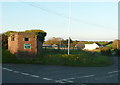
Pillbox at a crossroads, St Ishmael
Image: © Humphrey Bolton
Taken: 26 Oct 2016
0.22 miles
7
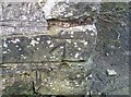
Ordnance Survey Cut Mark
This OS cut mark can be found on the roadside barn at Nimpwll Farm. It marks a point 130.626m above mean sea level.
Image: © Adrian Dust
Taken: 18 Jan 2022
0.23 miles