IMAGES TAKEN NEAR TO
FERRYSIDE, SA17 5YB
Introduction
This page details the photographs taken nearby to SA17 5YB by members of the Geograph project.
The Geograph project started in 2005 with the aim of publishing, organising and preserving representative images for every square kilometre of Great Britain, Ireland and the Isle of Man.

There are currently over 7.5m images from over14,400 individuals and you can help contribute to the project by visiting https://www.geograph.org.uk
Image Map
Images are licensed for reuse under creativecommons.org/licenses/by-sa/2.0
Notes
- Clicking on the map will re-center to the selected point.
- The higher the marker number, the further away the image location is from the centre of the postcode.
Image Listing (8 Images Found)
Images are licensed for reuse under creativecommons.org/licenses/by-sa/2.0
Image
Details
Distance
3
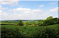
Farmland near Ferryside
Farmland near Ferryside as it gradually slopes down to the River Towy. The river itself can be seen in the middle distance.
Image: © Stuart Wilding
Taken: 18 May 2008
0.18 miles
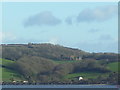
4
The derelict manor house of Iscoed overlooking Ferryside
http://carmarthenshirehistorian.org/cgi-bin/twiki/view/Historian/AnHistoricalViewOfIscoed
Image: © Peter Shaw
Taken: 13 Nov 2008
0.19 miles
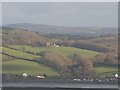
5

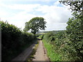
Road junction near Ferryside
Looking west towards Ferryside adjacent to the driveway to Tresilwood.
Image: © Simon Mortimer
Taken: 10 Aug 2012
0.20 miles
6
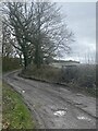
Heol fach wledig / Minor rural road
Heol fach wledig ger anhedd-dy o'r enw Bryncoch.
A minor road near a property known as Bryncoch (trans. red / brown hill).
Image: © Alan Richards
Taken: 29 Jul 2023
0.21 miles
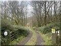
8
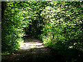
Footpath through woodland
View of the footpath as it makes its way towards Iscoed Home Fm.
Image: © Stuart Wilding
Taken: 18 May 2008
0.22 miles