IMAGES TAKEN NEAR TO
FERRYSIDE, SA17 5UG
Introduction
This page details the photographs taken nearby to SA17 5UG by members of the Geograph project.
The Geograph project started in 2005 with the aim of publishing, organising and preserving representative images for every square kilometre of Great Britain, Ireland and the Isle of Man.

There are currently over 7.5m images from over14,400 individuals and you can help contribute to the project by visiting https://www.geograph.org.uk
Image Map (Loading...)


Getting Data...Please wait
Leaflet Map data © OpenStreetMap
Images are licensed for reuse under creativecommons.org/licenses/by-sa/2.0
Notes
- Clicking on the map will re-center to the selected point.
- The higher the marker number, the further away the image location is from the centre of the postcode.
Image Listing (9 Images Found)
Images are licensed for reuse under creativecommons.org/licenses/by-sa/2.0
Image
Details
Distance
2

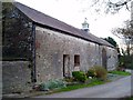
The Stable at Pengay Farm
Holiday accommodation at a former farm Image] in the hills above Ferryside
Image: © Eirian Evans
Taken: 24 May 2022
0.06 miles
3
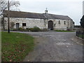
Pengay Farm, near Broadlay
The present house and farm buildings are 18th century with a former walled garden. The farmyard is entered through an arched gateway, and on the right of the archway is a bell dated 1760 from a wrecked Dutch ship.
Image: © Robin Lucas
Taken: 16 Nov 2013
0.07 miles
4
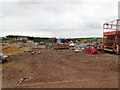
Waste site near Pengay Farm
The old farm buildings have been converted into luxury holiday accommodation, but this site is just a few metres away
Image: © Eirian Evans
Taken: 24 May 2022
0.09 miles
5
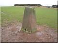
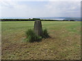
Triangulation Pillar (S2391)
Pen-Y-Gau 3rd Order Triangulation Pillar carries Flush Bracket S2391 which marks a point 131.981m above mean sea level.
Image: © Adrian Dust
Taken: 29 Feb 2008
0.13 miles
6
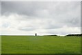
Pen-Y-Gau Trig Point between Llansaint & Ferryside
Image: © Colin Park
Taken: 14 Jul 2013
0.13 miles
8
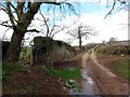
Trac Ffarm Pengay Farm Track
Hen heol yn agosau at Ffarm Pengay.
Old road approaching Pengay Farm.
Image: © Alan Richards
Taken: 4 Apr 2015
0.15 miles
9
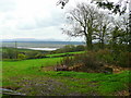
View to the coast
Looking south from near Pengay Farm over dairy pasture.
In the middle distance is the dark expanse of Pembrey Forest, and beyond that, the hills of The Gower.
Image: © Jonathan Billinger
Taken: 15 Oct 2008
0.19 miles