IMAGES TAKEN NEAR TO
Glan Tywi, FERRYSIDE, SA17 5TG
Introduction
This page details the photographs taken nearby to Glan Tywi, SA17 5TG by members of the Geograph project.
The Geograph project started in 2005 with the aim of publishing, organising and preserving representative images for every square kilometre of Great Britain, Ireland and the Isle of Man.

There are currently over 7.5m images from over14,400 individuals and you can help contribute to the project by visiting https://www.geograph.org.uk
Image Map (Loading...)


Getting Data...Please wait
Leaflet Map data © OpenStreetMap
Images are licensed for reuse under creativecommons.org/licenses/by-sa/2.0
Notes
- Clicking on the map will re-center to the selected point.
- The higher the marker number, the further away the image location is from the centre of the postcode.
Image Listing (40 Images Found)
Images are licensed for reuse under creativecommons.org/licenses/by-sa/2.0
Image
Details
Distance
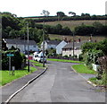
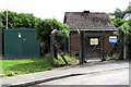
1
Glantywi, Ferryside
Houses on the south side of Carmarthen Road. Surprisingly for Carmarthenshire, where most signs are bilingual (Welsh & English) or Welsh only (such as the Glantywi street name sign seen here) http://www.geograph.org.uk/photo/4553594), the Caution Children Playing sign is in English only.
Image: © Jaggery
Taken: 4 Jul 2015
0.01 miles
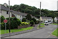
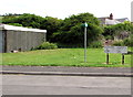
2
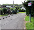
Houses on the edge of Ferryside
Looking south-east from Carmarthan Road along Glan Tywi.
Image: © Simon Mortimer
Taken: 10 Aug 2012
0.01 miles
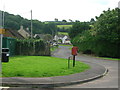
3
South along Glantywi, Ferryside
Viewed from the Carmarthen Road end. On the left, a green sign points right towards a recycling area. http://www.geograph.org.uk/photo/4553520
Image: © Jaggery
Taken: 4 Jul 2015
0.05 miles
4
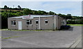
Ferryside Rugby & Social Club
Viewed from the street named Glantywi.
Image: © Jaggery
Taken: 4 Jul 2015
0.05 miles
5
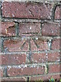
Ordnance Survey Cut Mark
This OS cut mark can be found on the wall of the old Police House on Glan Tywi. It marks a point 5.8857m above mean sea level.
Image: © Adrian Dust
Taken: 24 Jan 2015
0.05 miles
6
Tipping Prohibited notice, Glantywi, Ferryside
The Carmarthen District Council notice is next to a sign pointing to this http://www.geograph.org.uk/photo/4553520 recycling area.
Image: © Jaggery
Taken: 4 Jul 2015
0.06 miles
7
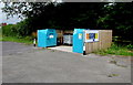
Recycling area, Ferryside
Set back from the street named Glantywi, opposite Ferryside Rugby & Social Club. http://www.geograph.org.uk/photo/4553503 Bilingual (Welsh and English) notices are on the fence. Only the following can be recycled here: mixed textiles & clothes; food & drink cans; newspapers & magazines; aerosols cans. All items are to be placed in the correct receptacle. Under no circumstances is anything to be left on the floor. This area is covered by CCTV.
Image: © Jaggery
Taken: 4 Jul 2015
0.06 miles
8
Electricity substation and a waste water pumping station, Glantywi, Ferryside
The identifier on the dark green Western Power Distribution electricity substation is
BRIARDALE FERRYSIDE S/S 526103.
The identifier on the Welsh Water facility on the right is
FERRYSIDE No. 4 WASTE WATER PUMPING STATION.
Image: © Jaggery
Taken: 4 Jul 2015
0.08 miles
9
No Cold Calling Area notice, Glantywi, Ferryside
On the corner of Carmarthen Road, the sign shows No Uninvited Sales People.
Image: © Jaggery
Taken: 4 Jul 2015
0.08 miles
10
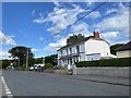
Carmarthen Road
Housing in Carmarthen Road on the outskirts of Ferryside.
Image: © Alan Hughes
Taken: 3 Aug 2020
0.08 miles