IMAGES TAKEN NEAR TO
Vicarage Close, FERRYSIDE, SA17 5SU
Introduction
This page details the photographs taken nearby to Vicarage Close, SA17 5SU by members of the Geograph project.
The Geograph project started in 2005 with the aim of publishing, organising and preserving representative images for every square kilometre of Great Britain, Ireland and the Isle of Man.

There are currently over 7.5m images from over14,400 individuals and you can help contribute to the project by visiting https://www.geograph.org.uk
Image Map (Loading...)


Getting Data...Please wait
Leaflet Map data © OpenStreetMap
Images are licensed for reuse under creativecommons.org/licenses/by-sa/2.0
Notes
- Clicking on the map will re-center to the selected point.
- The higher the marker number, the further away the image location is from the centre of the postcode.
Image Listing (167 Images Found)
Images are licensed for reuse under creativecommons.org/licenses/by-sa/2.0
Image
Details
Distance
1
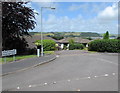
Vicarage Close, Ferryside
Viewed from Tri Pen Had Road.
Image: © Jaggery
Taken: 4 Jul 2015
0.02 miles
2

Ferryside: the post office
The post office is situated on the eastern side of the village square.
Image: © Chris Downer
Taken: 23 Feb 2009
0.02 miles
3

Ferryside: postbox № SA17 62
This George V-reign postbox is set into the wall of Image, and is emptied at 5pm on weekdays and at 11am on Saturdays.
The two stickers above the slot are the English and Welsh versions of text explaining that from 28 October 2007, Sunday collections will no longer take place. These appeared on all postboxes on the run-up to that date, those at post offices having received a Sunday collection and those elsewhere having had details of the nearest that was emptied on a Sunday.
In any case, the main collection plate, which is bilingual, has been updated to reflect these changes.
Image: © Chris Downer
Taken: 23 Feb 2009
0.02 miles
4
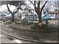
Ferryside: war memorial
Situated at the northeastern corner of the main village square, the war memorial has been added to in more recent years, with the Falkland War memorial on the right.
Image: © Chris Downer
Taken: 23 Feb 2009
0.02 miles
5
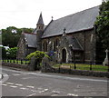
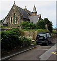
Church of St Thomas, Ferryside
Viewed across Water Street. The church is in the Parish of St Ishmael's with Llan-saint and Ferryside in the Church in Wales Diocese of St Davids. Built in 1876 in the Victorian Gothic style, replacing an earlier church on the site. Grade II listed in 2003.
Image: © Jaggery
Taken: 4 Jul 2015
0.03 miles
6
Ferryside: church of St. Thomas
A small church just to the northeast of the main square.
Image: © Chris Downer
Taken: 23 Feb 2009
0.03 miles
7

Tri Pen Had Road, Ferryside
Viewed across Portway.
Image: © Jaggery
Taken: 4 Jul 2015
0.03 miles
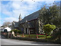
8
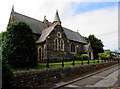
East side of the Church of St Thomas, Ferryside
Viewed across Water Street. The church is in the Parish of St Ishmael's with Llan-saint and Ferryside in the Church in Wales Diocese of St Davids. Built in 1876 in the Victorian Gothic style, replacing an earlier church on the site. Grade II listed in 2003.
Image: © Jaggery
Taken: 4 Jul 2015
0.03 miles
9
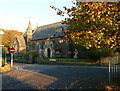
Church of St Thomas, Ferryside
Viewed across Water Street. The church is in the Parish of St Ishmael's with Llan-saint and Ferryside in the Church in Wales Diocese of St Davids. Built in 1876 in the Victorian Gothic style, replacing an earlier church on the site. Grade II listed in 2003.
Image: © Jaggery
Taken: 4 Jul 2015
0.03 miles
10
St Thomas's Church, Ferryside, St Ishmael
Image: © Humphrey Bolton
Taken: 26 Oct 2016
0.03 miles