IMAGES TAKEN NEAR TO
FERRYSIDE, SA17 5SF
Introduction
This page details the photographs taken nearby to SA17 5SF by members of the Geograph project.
The Geograph project started in 2005 with the aim of publishing, organising and preserving representative images for every square kilometre of Great Britain, Ireland and the Isle of Man.

There are currently over 7.5m images from over14,400 individuals and you can help contribute to the project by visiting https://www.geograph.org.uk
Image Map (Loading...)


Getting Data...Please wait
Leaflet Map data © OpenStreetMap
Images are licensed for reuse under creativecommons.org/licenses/by-sa/2.0
Notes
- Clicking on the map will re-center to the selected point.
- The higher the marker number, the further away the image location is from the centre of the postcode.
Image Listing (169 Images Found)
Images are licensed for reuse under creativecommons.org/licenses/by-sa/2.0
Image
Details
Distance
1
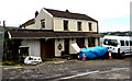
Beach Cottage, Ferryside
Located between Ferryside railway station level crossing and Ferryside beach.
Image: © Jaggery
Taken: 4 Jul 2015
0.00 miles
2
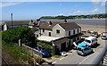
Beach Cottage, Ferryside
Beach Cottage is in the foreground, viewed from Ferryside railway station footbridge. http://www.geograph.org.uk/photo/4556925
In the background are Ferryside beach, the estuary of the River Towy
(Afon Tywi in Welsh) and Llansteffan on the far side of the estuary.
Image: © Jaggery
Taken: 4 Jul 2015
0.00 miles
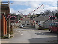
3
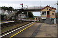
Ferryside railway station level crossing and footbridge
On the right, the signalbox at the edge of the station controls the level crossing barriers.
Viewed from the edge of The Square looking towards the beach.
Image: © Jaggery
Taken: 4 Jul 2015
0.01 miles
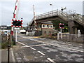
5
Ferryside: level crossing
The barriers are in the process of being raised, just after a train has sped by far too fast to have been stopping at the station, which is just out of picture to the left.
Image: © Chris Downer
Taken: 23 Feb 2009
0.01 miles
6
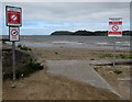
Public notices at the edge of Ferryside Beach
Two notices show No Parking - Emergency Access. The other one shows No Fouling - Clean Up After Your Dog. The notices are also in Welsh.
Image: © Jaggery
Taken: 4 Jul 2015
0.01 miles
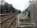
7
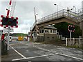
Level crossing and signal box, Ferryside
The railway line between Llanelli and Carmarthen opened in 1852, which enabled development of tourism in the area.
Image: © Rose and Trev Clough
Taken: 13 Oct 2008
0.01 miles
8
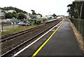
Ferryside railway station
Viewed from the NW end of platform 2, which is about 45 metres longer than platform 1.
Ferryside is a request stop on the West Wales Line in Carmarthenshire between Carmarthen and Kidwelly.
Stand to the right of the yellow line to reduce the effects of air turbulence created by a train passing by at high speed.
Image: © Jaggery
Taken: 4 Jul 2015
0.01 miles
9
Ferryside railway station footbridge and signalbox
The signalbox controls the level crossing barriers and adjacent signals at the SW end of the station on the
West Wales Line between Carmarthen and Kidwelly in Carmarthenshire. Stand to the right of the yellow
line to reduce the effects of air turbulence created by a train passing by at high speed.
Image: © Jaggery
Taken: 4 Jul 2015
0.01 miles
10
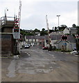
Foreshore side of Ferryside railway station level crossing
Looking towards Eva Terrace and The Square across the West Wales Line railway, from the beach at the edge of the River Towy estuary. Among the premises on the beach side are Ferryside Lifeboat Station http://www.geograph.org.uk/photo/4557021 and the River Towy Yacht Club. http://www.geograph.org.uk/photo/4556976
Image: © Jaggery
Taken: 4 Jul 2015
0.01 miles