IMAGES TAKEN NEAR TO
Water Street, FERRYSIDE, SA17 5RT
Introduction
This page details the photographs taken nearby to Water Street, SA17 5RT by members of the Geograph project.
The Geograph project started in 2005 with the aim of publishing, organising and preserving representative images for every square kilometre of Great Britain, Ireland and the Isle of Man.

There are currently over 7.5m images from over14,400 individuals and you can help contribute to the project by visiting https://www.geograph.org.uk
Image Map (Loading...)


Getting Data...Please wait
Leaflet Map data © OpenStreetMap
Images are licensed for reuse under creativecommons.org/licenses/by-sa/2.0
Notes
- Clicking on the map will re-center to the selected point.
- The higher the marker number, the further away the image location is from the centre of the postcode.
Image Listing (166 Images Found)
Images are licensed for reuse under creativecommons.org/licenses/by-sa/2.0
Image
Details
Distance
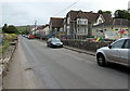
1
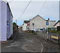
One way along Water Street, Ferryside
Viewed from Wellfield Terrace looking SW towards the centre of the village.
Image: © Jaggery
Taken: 4 Jul 2015
0.01 miles
2
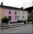
Pink house in Ferryside
Viewed across Eva Terrace.
Image: © Jaggery
Taken: 4 Jul 2015
0.03 miles
3
Ferryside School
Primary school viewed across Eva Terrace, Ferryside.
Image: © Jaggery
Taken: 4 Jul 2015
0.03 miles
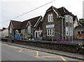
4
Ferryside School
Primary school viewed across Eva Terrace from Ferryside railway station.
Image: © Jaggery
Taken: 4 Jul 2015
0.03 miles
5
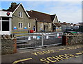
Water Street side of Ferryside School
A notice on the gates states NO ENTRY FOR VISITORS.
Please use the main entrance at the front (Eva Terrace) side of the school.
Image: © Jaggery
Taken: 4 Jul 2015
0.03 miles
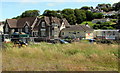
6
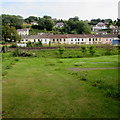
Eva Terrace viewed from Ferryside beach
The West Wales Line railway is between the lawn and Eva Terrace.
Image: © Jaggery
Taken: 16 Jul 2015
0.04 miles
7
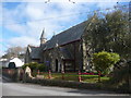
Ferryside: church of St. Thomas
A small church just to the northeast of the main square.
Image: © Chris Downer
Taken: 23 Feb 2009
0.04 miles
8
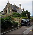
East side of the Church of St Thomas, Ferryside
Viewed across Water Street. The church is in the Parish of St Ishmael's with Llan-saint and Ferryside in the Church in Wales Diocese of St Davids. Built in 1876 in the Victorian Gothic style, replacing an earlier church on the site. Grade II listed in 2003.
Image: © Jaggery
Taken: 4 Jul 2015
0.04 miles
9
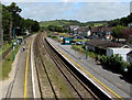
Ferryside railway station
Viewed from the station footbridge. http://www.geograph.org.uk/photo/4577363 Ferryside station in Carmarthenshire is a request stop on the West Wales Line between Kidwelly and Carmarthen. Platform 2 on the left is for trains to Carmarthen.
Image: © Jaggery
Taken: 4 Jul 2015
0.05 miles
10
Eva Terrace, Ferryside
Looking NE past the village school. http://www.geograph.org.uk/photo/4558413
Image: © Jaggery
Taken: 4 Jul 2015
0.05 miles