IMAGES TAKEN NEAR TO
Llandyfaelog, KIDWELLY, SA17 5NR
Introduction
This page details the photographs taken nearby to SA17 5NR by members of the Geograph project.
The Geograph project started in 2005 with the aim of publishing, organising and preserving representative images for every square kilometre of Great Britain, Ireland and the Isle of Man.

There are currently over 7.5m images from over14,400 individuals and you can help contribute to the project by visiting https://www.geograph.org.uk
Image Map (Loading...)


Getting Data...Please wait
Leaflet Map data © OpenStreetMap
Images are licensed for reuse under creativecommons.org/licenses/by-sa/2.0
Notes
- Clicking on the map will re-center to the selected point.
- The higher the marker number, the further away the image location is from the centre of the postcode.
Image Listing (15 Images Found)
Images are licensed for reuse under creativecommons.org/licenses/by-sa/2.0
Image
Details
Distance
1
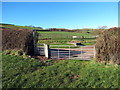
Llwybr Pont Rhydonnen Path
Llwybr cyhoeddus yn mynd i gyfeiriad Pont Rhydonnen.
A public footpath heading in the direction of Pont Rhydonnen (trans. ashford bridge).
Image: © Alan Richards
Taken: 24 Feb 2016
0.15 miles
2
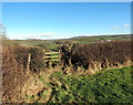
Llwybr Coedlline / Coedlline path
Sticil ar lwybr cyhoeddus yn arwain at Ffarm Coedlline.
A stile on a path heading in the direction of Coedlline Farm.
Image: © Alan Richards
Taken: 24 Feb 2016
0.16 miles
3
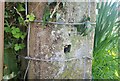
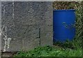
Ordnance Survey Cut Mark
This OS cut mark can be found on the concrete gatepost west side of the road. It marks a point 50.415m above mean sea level.
Image: © Adrian Dust
Taken: 30 Mar 2021
0.17 miles
4
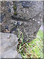
Ordnance Survey Cut Mark (Remains)
This badly damaged OS cut mark can be found on the corner of the roadside building at Meidrym Farm. It marked a point 31.923m above mean sea level.
Image: © Adrian Dust
Taken: 24 Jan 2015
0.17 miles
5

Ystrad Fawr
Track leading through Meidrim to Ystrad Fawr.
Image: © Alan Hughes
Taken: 23 Jan 2019
0.18 miles
6
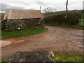
Outbuilding at Meidrim Farm
Muddy entrance to Meidrim Farm, Llandyfaelog.
Image: © Alan Hughes
Taken: 23 Jan 2019
0.18 miles
8
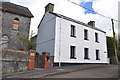
White house beside the old chapel - Llandyfaelog
Image: © Mick Lobb
Taken: 7 Apr 2009
0.20 miles
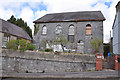
10
Ordnance Survey Cut Mark
This OS cut mark can be found on the chapel north side of the road. It marks a point 64.028m above mean sea level.
Image: © Adrian Dust
Taken: 30 Mar 2021
0.21 miles