IMAGES TAKEN NEAR TO
Llansaint, KIDWELLY, SA17 5JS
Introduction
This page details the photographs taken nearby to SA17 5JS by members of the Geograph project.
The Geograph project started in 2005 with the aim of publishing, organising and preserving representative images for every square kilometre of Great Britain, Ireland and the Isle of Man.

There are currently over 7.5m images from over14,400 individuals and you can help contribute to the project by visiting https://www.geograph.org.uk
Image Map (Loading...)


Getting Data...Please wait
Leaflet Map data © OpenStreetMap
Images are licensed for reuse under creativecommons.org/licenses/by-sa/2.0
Notes
- Clicking on the map will re-center to the selected point.
- The higher the marker number, the further away the image location is from the centre of the postcode.
Image Listing (10 Images Found)
Images are licensed for reuse under creativecommons.org/licenses/by-sa/2.0
Image
Details
Distance
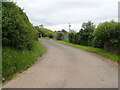
2
Wales Coast Path
Between Penallt Farm and Llansaint
Image: © Eirian Evans
Taken: 23 May 2022
0.09 miles
3
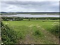
View over the Gwendraeth Estuary
From half-way up the hill to Llansaint on the Wales Coast Path.
Image: © Eirian Evans
Taken: 23 May 2022
0.12 miles
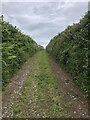
5
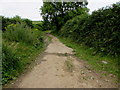
Wales Coast Path from Penallt Farm towards Llansaint
The path heads north towards Llansaint away from the farm. http://www.geograph.org.uk/photo/4576638 The Wales Coast Path is a 1,400km long path for walkers and cyclists alongside or near most of the coastline of Wales.
Image: © Jaggery
Taken: 16 Jul 2015
0.22 miles
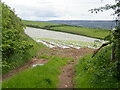
6
Welsh Coast Path
The path turns off the road near Penallt Farm, and heads uphill along this track on its way to Ferryside. I wouldn't recommend it for any vehicle, never mind heavy goods vehicles
Image: © Eirian Evans
Taken: 23 May 2022
0.23 miles
7
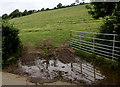
Muddy entrance to a hillside field near Penallt Farm west of Kidwelly
On the north side of the coastal road from Ferryside to Kidwelly in rural Carmarthenshire.
Image: © Jaggery
Taken: 16 Jul 2015
0.24 miles
8
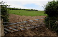
Distorted field gate opposite Penallt Farm west of Kidwelly
On the north side of the coastal road from Ferryside to Kidwelly in rural Carmarthenshire.
Image: © Jaggery
Taken: 16 Jul 2015
0.24 miles
9
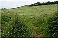
Hillside field west of Kidwelly
Viewed across this http://www.geograph.org.uk/photo/4576623 oblique gate to a field on the north side
of the coastal road from Ferryside to Kidwelly in rural Carmarthenshire.
Image: © Jaggery
Taken: 16 Jul 2015
0.24 miles
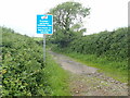
10
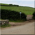
Wales Coast Path signs opposite Penallt Farm west of Kidwelly
On the north side of the coastal road from Ferryside to Kidwelly in rural Carmarthenshire. The Wales Coast Path is a 1,400km long path for walkers and cyclists alongside or near most of the coastline of Wales.
Image: © Jaggery
Taken: 16 Jul 2015
0.25 miles