IMAGES TAKEN NEAR TO
Llansaint, KIDWELLY, SA17 5EZ
Introduction
This page details the photographs taken nearby to SA17 5EZ by members of the Geograph project.
The Geograph project started in 2005 with the aim of publishing, organising and preserving representative images for every square kilometre of Great Britain, Ireland and the Isle of Man.

There are currently over 7.5m images from over14,400 individuals and you can help contribute to the project by visiting https://www.geograph.org.uk
Image Map (Loading...)


Getting Data...Please wait
Leaflet Map data © OpenStreetMap
Images are licensed for reuse under creativecommons.org/licenses/by-sa/2.0
Notes
- Clicking on the map will re-center to the selected point.
- The higher the marker number, the further away the image location is from the centre of the postcode.
Image Listing (9 Images Found)
Images are licensed for reuse under creativecommons.org/licenses/by-sa/2.0
Image
Details
Distance
1
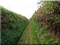
Heol y Cockle Way
Ceuffordd hynafol yn arwain tuag at bentre Llansaint. Enw'r hewl yw'r Cockleway oherwydd dyma'r ffordd y teithiai menywod y pentre a'u hasynnod yn ddyddiol i lawr i'r traeth i gocsa.
Ancient hollow way heading in the direction of Llansaint. The name of the road is Cockle Way after the women and their donkeys who travelled daily along its length to the cockle beds at St Ishmael.
Image: © Alan Richards
Taken: 16 Apr 2015
0.11 miles
2

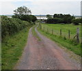
Heol Bryn y Mor Road
Heol yn arwain i lawr o Ffarm Bryn y Môr
Access road leading down from Bryn y Môr Farm.
Image: © Alan Richards
Taken: 16 Apr 2015
0.19 miles
3
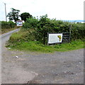
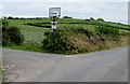
Junction for Marsh Water Ponds coarse fishery near Kidwelly
Diverging from the coastal road from Ferryside to Kidwelly in rural Carmarthenshire,
the road http://www.geograph.org.uk/photo/4574092 on the right leads to the fishery on the north bank of the Gwendraeth estuary.
Image: © Jaggery
Taken: 16 Jul 2015
0.20 miles
4
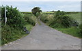
Bridleway and access road to Bryn-y-M?r Farm near Kidwelly
From the north side of the coastal road from Ferryside to Kidwelly in rural Carmarthenshire.
The sign on the left indicates a bridleway.
Image: © Jaggery
Taken: 16 Jul 2015
0.20 miles
5
Entrance road to Marsh Water Ponds coarse fishery near Kidwelly
From the south side of the coastal road from Ferryside to Kidwelly in rural Carmarthenshire.
Nearby notices state that day tickets are available for the fishery which is open from dawn till dusk.
The coarse fish in the fishery are carp, perch, roach and tench. In July 2015, rod hire is available for £5.
Image: © Jaggery
Taken: 16 Jul 2015
0.22 miles
6
Left here for happy eggs, dog holidays and logs, Bryn-y-M?r Farm near Kidwelly
The sign faces the coastal road from Ferryside to Kidwelly in rural Carmarthenshire.
Image: © Jaggery
Taken: 16 Jul 2015
0.22 miles
7
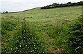
Hillside field west of Kidwelly
Viewed across this http://www.geograph.org.uk/photo/4576623 oblique gate to a field on the north side
of the coastal road from Ferryside to Kidwelly in rural Carmarthenshire.
Image: © Jaggery
Taken: 16 Jul 2015
0.24 miles
8
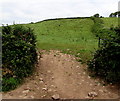
Open access to a field near Kidwelly
On the north side of the coastal road from Ferryside to Kidwelly in rural Carmarthenshire.
The edge of the gate is on the right.
Image: © Jaggery
Taken: 16 Jul 2015
0.24 miles
9
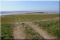
View out to sea
View out to sea from below Llansaint.
Image: © Philip Halling
Taken: 6 Apr 2013
0.25 miles