IMAGES TAKEN NEAR TO
Llangyndeyrn, KIDWELLY, SA17 5EN
Introduction
This page details the photographs taken nearby to SA17 5EN by members of the Geograph project.
The Geograph project started in 2005 with the aim of publishing, organising and preserving representative images for every square kilometre of Great Britain, Ireland and the Isle of Man.

There are currently over 7.5m images from over14,400 individuals and you can help contribute to the project by visiting https://www.geograph.org.uk
Image Map (21 Images)


Getting Data...Please wait
Leaflet Map data © OpenStreetMap
Images are licensed for reuse under creativecommons.org/licenses/by-sa/2.0
Notes
- Clicking on the map will re-center to the selected point.
- The higher the marker number, the further away the image location is from the centre of the postcode.
Image Listing (21 Images Found)
Images are licensed for reuse under creativecommons.org/licenses/by-sa/2.0
Image
Details
Distance
1
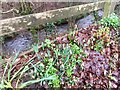
Changing Seasons
Autumn leaves, winter snowdrops and the developing foliage of springtime daffodils to come. The stream flows by, having seen it all before.
Image: © Alan Hughes
Taken: 23 Jan 2019
0.06 miles
2
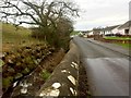
Stream at Llangyndeyrn
Stream running alongside the road at Llangyndeyrn before joining the Gwendraeth.
Image: © Alan Hughes
Taken: 23 Jan 2019
0.09 miles
3
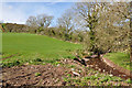
Tributary stream of the Gwedndraeth Fach at Llangyndeyrn
Image: © Mick Lobb
Taken: 7 Apr 2009
0.09 miles
5
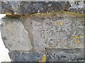
Ordnance Survey Cut Mark
This OS cut mark can be found on the wall post of the Bethel Chapel. It marks a point 52.483m above mean sea level.
Image: © Adrian Dust
Taken: 18 Apr 2023
0.12 miles
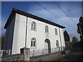
6
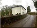
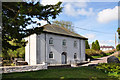
Bethel Baptist Chapel
Welsh Baptist Chapel at Llangyndeyrn.
Image: © Alan Hughes
Taken: 23 Jan 2019
0.13 miles
7
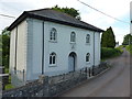
The Bethel Baptist Chapel north of Llangyndeyrn
This, and its attached vestry to the rear, were given a Grade II listing https://www.britishlistedbuildings.co.uk/300022270-bethel-baptist-chapel-and-attached-vestry-llangyndeyrn#.WUPrbtQrLGg in 1999. It was originally built in 1797, then altered and rebuilt in the early 1840s, and updated in 1904. Described as "a well-preserved hipped-roof chapel of c1840"
Image: © Richard Law
Taken: 1 Jun 2017
0.13 miles
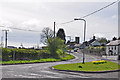
10
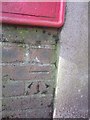
Ordnance Survey Cut Mark
This OS cut mark can be found below the letter box to the SW of the road. It marks a point 49.582m above mean sea level.
Image: © Adrian Dust
Taken: 8 Mar 2014
0.14 miles