IMAGES TAKEN NEAR TO
Glanafon, KIDWELLY, SA17 5EL
Introduction
This page details the photographs taken nearby to Glanafon, SA17 5EL by members of the Geograph project.
The Geograph project started in 2005 with the aim of publishing, organising and preserving representative images for every square kilometre of Great Britain, Ireland and the Isle of Man.

There are currently over 7.5m images from over14,400 individuals and you can help contribute to the project by visiting https://www.geograph.org.uk
Image Map
Images are licensed for reuse under creativecommons.org/licenses/by-sa/2.0
Notes
- Clicking on the map will re-center to the selected point.
- The higher the marker number, the further away the image location is from the centre of the postcode.
Image Listing (24 Images Found)
Images are licensed for reuse under creativecommons.org/licenses/by-sa/2.0
Image
Details
Distance
1
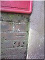
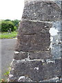
Ordnance Survey Cut Mark
This OS cut mark can be found below the letter box to the SW of the road. It marks a point 49.582m above mean sea level.
Image: © Adrian Dust
Taken: 8 Mar 2014
0.01 miles
3
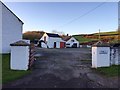
Fferm y Llandre
Entrance to farm in the village of Llangyndeyrn.
Image: © Alan Hughes
Taken: 5 Nov 2017
0.06 miles
4
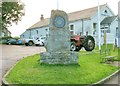
Commemoration stone at Llangyndeyrn
This photo was taken during the week of celebrations of the 50th anniversary of the village of Llangyndeyrn's salvation from being flooded. The stone stands beside the main road outside the church hall of St Cyndeyrn's Church.
In 1960 the Swansea Water Corporation chose the section of the Gwendraeth Fach valley from Llangyndeyrn up to Porthyrhyd as their preferred (i.e. cheapest) of six possible sites to create a new reservoir.
When the inhabitants read about this in the newspaper they immediately gathered together and swore to fight the project to the bitter end. By blockading field entrances and protesting they drove the unwanted visitors away resulting in an alternative site being chosen in 1963.
This is why there is now a reservoir at Llyn Brianne Image
The centre of the plaque on the commemorative stone bears the phrase "MEWN UNDOD MAE NERTH" which translates to "Strength in Unity".
See also http://www.bbc.co.uk/news/uk-wales-south-west-wales-24584865
Image: © Nigel Davies
Taken: 22 Oct 2013
0.06 miles
5
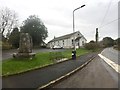
Church Hall
Church hall at Llangyndeyrn.
Image: © Alan Hughes
Taken: 23 Jan 2019
0.07 miles

7
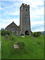
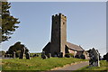
Church of St Cyndeyrn
The village church, given a Grade II* listing https://www.britishlistedbuildings.co.uk/300009399-church-of-st-cyndeyrn-llangyndeyrn#.WUPvz9QrLGg in 1966. Parts of the building's exterior date back to the 14th, 15th and 16th centuries, with similar features retained inside too, but as might be expected there have been extensions and alterations & repairs over the years, the most recent of note being the addition of a stained glass window in 1979.
Image: © Richard Law
Taken: 1 Jun 2017
0.10 miles
8
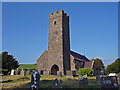
Llangyndeyrn Parish Church
The large parish of Llangyndeyrn (once spelt Llangendeirne) gets its name from the wandering British saint Cyndeyrn, to whom the church is dedicated. Cyndeyrn (Old British: Kentigernos) is conceivably the Kentigern who also founded Glasgow, where he is known as St Mungo. The large circular churchyard testifies to its great age.
Image: © Dylan Moore
Taken: 24 Sep 2008
0.10 miles
9
OS benchmark - Llangyndeyrn, church tower
An OS cutmark at the base of the tower, which was originally levelled at 57.184m above Ordnance Datum Newlyn.
Image: © Richard Law
Taken: 1 Jun 2017
0.11 miles