IMAGES TAKEN NEAR TO
Crwbin, KIDWELLY, SA17 5DA
Introduction
This page details the photographs taken nearby to SA17 5DA by members of the Geograph project.
The Geograph project started in 2005 with the aim of publishing, organising and preserving representative images for every square kilometre of Great Britain, Ireland and the Isle of Man.

There are currently over 7.5m images from over14,400 individuals and you can help contribute to the project by visiting https://www.geograph.org.uk
Image Map
Images are licensed for reuse under creativecommons.org/licenses/by-sa/2.0
Notes
- Clicking on the map will re-center to the selected point.
- The higher the marker number, the further away the image location is from the centre of the postcode.
Image Listing (12 Images Found)
Images are licensed for reuse under creativecommons.org/licenses/by-sa/2.0
Image
Details
Distance
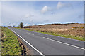
1
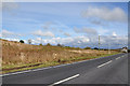
The B4306 looking south west toward Bancfosffelen
Image: © Mick Lobb
Taken: 7 Apr 2009
0.08 miles
2
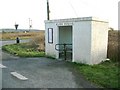
Garn Ganol bus shelter
A curious bus shelter with its own integral turnstile. Hardly necessary, given the small interior.
Closer inspection reveals that the 2 "G"s in the cement title above the doorway have been moulded upside down.
Image: © Nigel Davies
Taken: 4 Feb 2007
0.09 miles
3
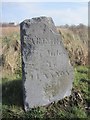
Broken Mile Stone
This Mile Stone has an OS rivet on the top. http://www.geograph.org.uk/photo/3876964
Image: © Adrian Dust
Taken: 8 Mar 2014
0.10 miles
4
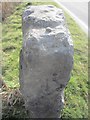
Ordnance Survey Rivet
This OS rivet can be found on the mile stone to the NE of the road. It marks a point 214.2m above mean sea level. http://www.geograph.org.uk/photo/3876960
Image: © Adrian Dust
Taken: 8 Mar 2014
0.10 miles
5
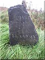
Old Milestone by the B4306, southeast of Crwbin, Llangyndeyrn parish
Milestone by the B4306, in parish of Llangyndeyrn (Carmarthenshire District), Southeast of Crwbin.
Inscription reads:-
(C)ARMART(HEN)
7 M
LLANNON
5 M
Rivet benchmark recorded on top - lost to damage.
Surveyed
Milestone Society National ID: CAM_CMLN07
Image: © Milestone Society
Taken: Unknown
0.10 miles
6
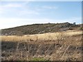
Rock slab on Mynydd Llangyndeyrn
This giant slab of rock is very near the road to the southwest. It is typical of the many prominences on this mountain top and probably explains why it is quarried. On one side is an inclined flat slab. Around the other are the cracked and broken layers revealed by the inclination.
Image: © Nigel Davies
Taken: 4 Feb 2007
0.10 miles
7
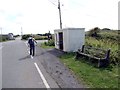
Arhosfan fysys / Bus Stop
Cerddwyr yn mynd heibio i hen arhosfan fysys gyda gat dro ger Bancffosfelen
Walkers passing an old bus stop with turnstile near Bancffosfelen (trans. bank of brown ditch).
Image: © Alan Richards
Taken: 31 Aug 2014
0.11 miles
8
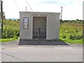
Carn Canol bus shelter
One wonders initially why there is a sort of turnstile blocking the doorway, but the shelter stands on open common land where there are ponies and sheep. The turnstile is obviously there to prevent animals from leaving small deposits on the floor, or from catching the bus to Carmarthen.
Image: © Gordon Hatton
Taken: 1 Sep 2014
0.12 miles
10
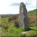
Standing stone, Mynydd Llangyndeyrn
Large standing stone [over 2m tall above ground] towards the SE end of this patch of rocky open ground.
Image: © Gordon Hatton
Taken: 1 Sep 2014
0.14 miles