IMAGES TAKEN NEAR TO
Crwbin, KIDWELLY, SA17 5BU
Introduction
This page details the photographs taken nearby to SA17 5BU by members of the Geograph project.
The Geograph project started in 2005 with the aim of publishing, organising and preserving representative images for every square kilometre of Great Britain, Ireland and the Isle of Man.

There are currently over 7.5m images from over14,400 individuals and you can help contribute to the project by visiting https://www.geograph.org.uk
Image Map (Loading...)


Getting Data...Please wait
Leaflet Map data © OpenStreetMap
Images are licensed for reuse under creativecommons.org/licenses/by-sa/2.0
Notes
- Clicking on the map will re-center to the selected point.
- The higher the marker number, the further away the image location is from the centre of the postcode.
Image Listing (12 Images Found)
Images are licensed for reuse under creativecommons.org/licenses/by-sa/2.0
Image
Details
Distance
1
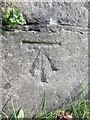
Ordnance Survey Cut Mark
This OS cut mark can be found on the wall to the north of the road. It marks a point 140.18m above mean sea level.
Image: © Adrian Dust
Taken: 8 Mar 2014
0.05 miles
2
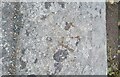
Ordnance Survey Rivet
This OS rivet can be found on the low wall at Ty Cam. It marks a point 156.880m above mean sea level.
Image: © Adrian Dust
Taken: 1 May 2021
0.09 miles
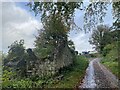
3
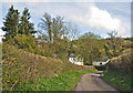
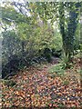
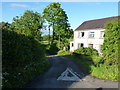
Lane off the B4306 between Llangyndeyrn and Crwbin
Image: © Mick Lobb
Taken: 7 Apr 2009
0.10 miles
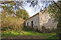
7

Derelict barn or farm building
The roof that was just hanging on 8 years ago in Image has now fallen in completely, and this small bar is little more than a set of walls.
Image: © Richard Law
Taken: 2 Jun 2017
0.13 miles
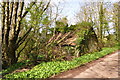
8
Farm buildings off the B4306 between Llangyndeyrn and Crwbin
The roof of the farmhouse can just be seen over the top of the main building in the photograph.
Image: © Mick Lobb
Taken: 7 Apr 2009
0.14 miles
9
Rural ruin on lane off the B4306 between Llangyndeyrn and Crwbin
Probably a small barn but, because of its condition, difficult to tell.
Image: © Mick Lobb
Taken: 7 Apr 2009
0.15 miles
10
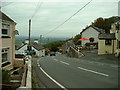
House at the lane junction
This house is set into the angle of the B4306 and the lane to Torcoed Fawr.
Image: © Richard Law
Taken: 2 Jun 2017
0.21 miles