IMAGES TAKEN NEAR TO
KIDWELLY, SA17 5BB
Introduction
This page details the photographs taken nearby to SA17 5BB by members of the Geograph project.
The Geograph project started in 2005 with the aim of publishing, organising and preserving representative images for every square kilometre of Great Britain, Ireland and the Isle of Man.

There are currently over 7.5m images from over14,400 individuals and you can help contribute to the project by visiting https://www.geograph.org.uk
Image Map (Loading...)


Getting Data...Please wait
Leaflet Map data © OpenStreetMap
Images are licensed for reuse under creativecommons.org/licenses/by-sa/2.0
Notes
- Clicking on the map will re-center to the selected point.
- The higher the marker number, the further away the image location is from the centre of the postcode.
Image Listing (5 Images Found)
Images are licensed for reuse under creativecommons.org/licenses/by-sa/2.0
Image
Details
Distance
1
Water Street, Kidwelly
Leaving Kidwelly along Water Street, heading for Carmarthen.
Image: © Peter Kazmierczak
Taken: 8 Aug 2013
0.10 miles
2
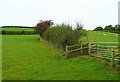
Sheep pasture west of Rogerlay Farm
The western slope of the Gwendraeth Fach valley.
Image: © Jonathan Billinger
Taken: 15 Oct 2008
0.20 miles
3
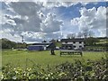
Broadland Farm
Farm close to the Gwendraeth Fach.
Image: © Alan Hughes
Taken: 5 May 2021
0.23 miles
4
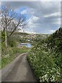
Country lane
Country road leading to Rogerlay Farm.
Image: © Alan Hughes
Taken: 5 May 2021
0.24 miles
5
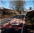
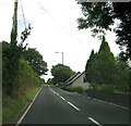
30 to 40 at the edge of Kidwelly
Beyond the end of roadside houses, the 30mph speed limit increases to 40mph.
Water Street behind the camera is here Carmarthen Road. The A484 junction is out of shot ahead.
Image: © Jaggery
Taken: 29 Mar 2013
0.24 miles