IMAGES TAKEN NEAR TO
Carmarthen Road, KIDWELLY, SA17 5AG
Introduction
This page details the photographs taken nearby to Carmarthen Road, SA17 5AG by members of the Geograph project.
The Geograph project started in 2005 with the aim of publishing, organising and preserving representative images for every square kilometre of Great Britain, Ireland and the Isle of Man.

There are currently over 7.5m images from over14,400 individuals and you can help contribute to the project by visiting https://www.geograph.org.uk
Image Map (Loading...)


Getting Data...Please wait
Leaflet Map data © OpenStreetMap
Images are licensed for reuse under creativecommons.org/licenses/by-sa/2.0
Notes
- Clicking on the map will re-center to the selected point.
- The higher the marker number, the further away the image location is from the centre of the postcode.
Image Listing (2 Images Found)
Images are licensed for reuse under creativecommons.org/licenses/by-sa/2.0
Image
Details
Distance
2
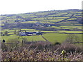
Gwendraeth Valley from Mynydd-y-Garreg
The farm in the foreground is Gwenllian Farm and in the distance you can see the old Corporation Arms and Bryn Gwendraeth house where I lived 40 years ago. The photograph was taken outside Horeb Chapel.
Image: © Dai Darkin
Taken: 15 Aug 2004
0.12 miles